


Is Thingvellir National Park a Volcano?

The Short Answer: No, but it's the engine that drives them.
If you are standing in Þingvellir National Park looking around the horizon for a classic, cone-shaped mountain spewing lava, you aren't going to find one. Þingvellir is not a single volcano. However, the forces that created this breathtaking national park are the exact same forces that fuel every single eruption in Iceland.
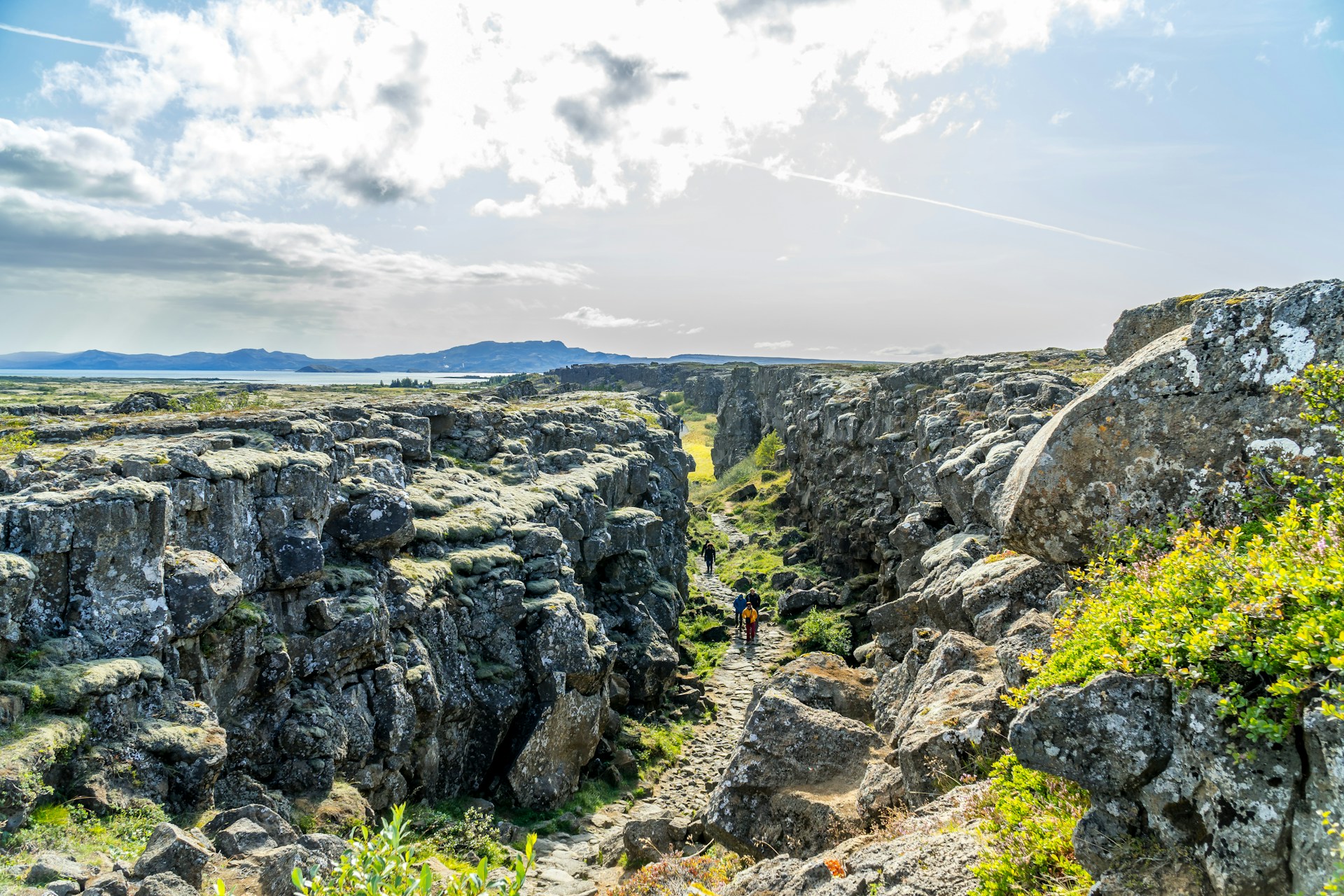
When you walk down the pathway into the famous Almannagjá gorge, you aren't just taking a stroll through a pretty valley. You are walking directly through a massive, highly active volcanic rift zone.
Walking Between Two Continents
To truly understand Þingvellir, you have to look at the bigger picture of why Iceland exists in the first place. The entire island sits squarely on top of the Mid-Atlantic Ridge, a colossal underwater mountain range where the North American and Eurasian tectonic plates are slowly pulling apart.
In most parts of the world, this violent separation happens deep in the dark at the bottom of the ocean. But in Iceland, it happens right out in the open air. When you visit Þingvellir, you are standing in the physical rift valley created by these two massive plates drifting away from each other at a rate of about 2 centimeters (nearly an inch) per year. The deep cracks, dramatic fissures, and stunning vertical rock walls of the park are the physical scars of the Earth tearing itself open.
If you want proof of this constant movement, look no further than Silfra. This famous fissure, filled with some of the clearest glacial water on the planet, is quite literally a crack between the continents that widens a tiny bit more every year.
The Magma Beneath Your Feet
So, if the ground is tearing open, why isn't there an active volcano erupting right there?
There is magma deep beneath Þingvellir, but currently, it isn't finding a clear path to the surface in that specific spot. However, the park is a crucial part of a larger, highly active volcanic system called Hengill. If you know what to look for, the evidence of past volcanic violence is everywhere.
The vast, flat plains of Þingvellir are completely covered in ancient lava fields, overgrown with thick green moss. Even the beautiful, crystal-clear lake (Þingvallavatn) fills a massive depression created by tectonic sinking and ancient lava dams. The area hasn't seen an eruption in about 2,000 years, but it is very much alive, fueling the geothermal hot springs and power plants just a few miles down the road.
Why the Vikings Chose a Fault Line
The geology of Þingvellir didn't just shape the landscape; it shaped the nation. When the early Viking settlers were looking for a place to hold their annual parliament (the Alþingi) in 930 AD, they chose this exact spot. Why? Because the massive, sheer rock wall of the Almannagjá fault line acted as a natural acoustic amplifier. When the Lawspeaker stood in front of the cliff, his voice carried across the entire valley. Iceland’s history was literally built on the edge of a shifting tectonic plate.
See the Big Picture Before You Go
Before you drive the Golden Circle to walk between the tectonic plates, you should see exactly how all these incredible forces connect.
At Volcano Express, located inside the iconic Harpa Concert Hall in downtown Reykjavik, our interactive Pre-Show area features a massive, illuminated map of Iceland. We have tracked every single one of the 247 recorded eruptions since the island was settled by the Vikings. You can clearly see how the dramatic rift valley of Þingvellir connects directly to the highly active volcanic zones of Reykjanes and the fiery glaciers of the highlands.
Once you understand the map, step into our 15-minute, 4K cinematic simulator. With subsonic sound and dynamic motion seating, you can safely feel the 1,100°C heat and the physical rumble of the eruptions that created the very ground you'll be walking on later that day. It’s the perfect, thrilling start to your Icelandic adventure.
This article is part of our complete guide: Volcanic Science & Iceland Geology.
Is Thingvellir National Park a Volcano?
The Short Answer: No, but it's the engine that drives them.
If you are standing in Þingvellir National Park looking around the horizon for a classic, cone-shaped mountain spewing lava, you aren't going to find one. Þingvellir is not a single volcano. However, the forces that created this breathtaking national park are the exact same forces that fuel every single eruption in Iceland.
When you walk down the pathway into the famous Almannagjá gorge, you aren't just taking a stroll through a pretty valley. You are walking directly through a massive, highly active volcanic rift zone.
Walking Between Two Continents
To truly understand Þingvellir, you have to look at the bigger picture of why Iceland exists in the first place. The entire island sits squarely on top of the Mid-Atlantic Ridge, a colossal underwater mountain range where the North American and Eurasian tectonic plates are slowly pulling apart.
In most parts of the world, this violent separation happens deep in the dark at the bottom of the ocean. But in Iceland, it happens right out in the open air. When you visit Þingvellir, you are standing in the physical rift valley created by these two massive plates drifting away from each other at a rate of about 2 centimeters (nearly an inch) per year. The deep cracks, dramatic fissures, and stunning vertical rock walls of the park are the physical scars of the Earth tearing itself open.
If you want proof of this constant movement, look no further than Silfra. This famous fissure, filled with some of the clearest glacial water on the planet, is quite literally a crack between the continents that widens a tiny bit more every year.
The Magma Beneath Your Feet
So, if the ground is tearing open, why isn't there an active volcano erupting right there?
There is magma deep beneath Þingvellir, but currently, it isn't finding a clear path to the surface in that specific spot. However, the park is a crucial part of a larger, highly active volcanic system called Hengill. If you know what to look for, the evidence of past volcanic violence is everywhere.
The vast, flat plains of Þingvellir are completely covered in ancient lava fields, overgrown with thick green moss. Even the beautiful, crystal-clear lake (Þingvallavatn) fills a massive depression created by tectonic sinking and ancient lava dams. The area hasn't seen an eruption in about 2,000 years, but it is very much alive, fueling the geothermal hot springs and power plants just a few miles down the road.
Why the Vikings Chose a Fault Line
The geology of Þingvellir didn't just shape the landscape; it shaped the nation. When the early Viking settlers were looking for a place to hold their annual parliament (the Alþingi) in 930 AD, they chose this exact spot. Why? Because the massive, sheer rock wall of the Almannagjá fault line acted as a natural acoustic amplifier. When the Lawspeaker stood in front of the cliff, his voice carried across the entire valley. Iceland’s history was literally built on the edge of a shifting tectonic plate.
See the Big Picture Before You Go
Before you drive the Golden Circle to walk between the tectonic plates, you should see exactly how all these incredible forces connect.
At Volcano Express, located inside the iconic Harpa Concert Hall in downtown Reykjavik, our interactive Pre-Show area features a massive, illuminated map of Iceland. We have tracked every single one of the 247 recorded eruptions since the island was settled by the Vikings. You can clearly see how the dramatic rift valley of Þingvellir connects directly to the highly active volcanic zones of Reykjanes and the fiery glaciers of the highlands.
Once you understand the map, step into our 15-minute, 4K cinematic simulator. With subsonic sound and dynamic motion seating, you can safely feel the 1,100°C heat and the physical rumble of the eruptions that created the very ground you'll be walking on later that day. It’s the perfect, thrilling start to your Icelandic adventure.
This article is part of our complete guide: Volcanic Science & Iceland Geology.


.webp)
.jpg)


