Iceland's Volcanoes Explained: Geology, Eruptions & Geothermal Power
Why Iceland has more active volcanoes than anywhere on Earth — the Mid-Atlantic Ridge, the hotspot, 32 systems, and how a country runs on volcanic heat.
Jul 6, 2026
Fred Johnson
Last updated: May 2026
Key takeaways from this guide
Iceland sits on the Mid-Atlantic Ridge AND a deep mantle hotspot — the only place on Earth with both — producing 32 active volcanic systems and roughly 130 volcanic peaks on an island the size of Portugal.
An eruption occurs somewhere in Iceland on average every 4–5 years, the most concentrated active volcanism anywhere on Earth.
Iceland produces nearly every known eruption type — Hawaiian, Strombolian, Vulcanian, Plinian, and phreatomagmatic — making it one of the best places to study volcanoes globally.
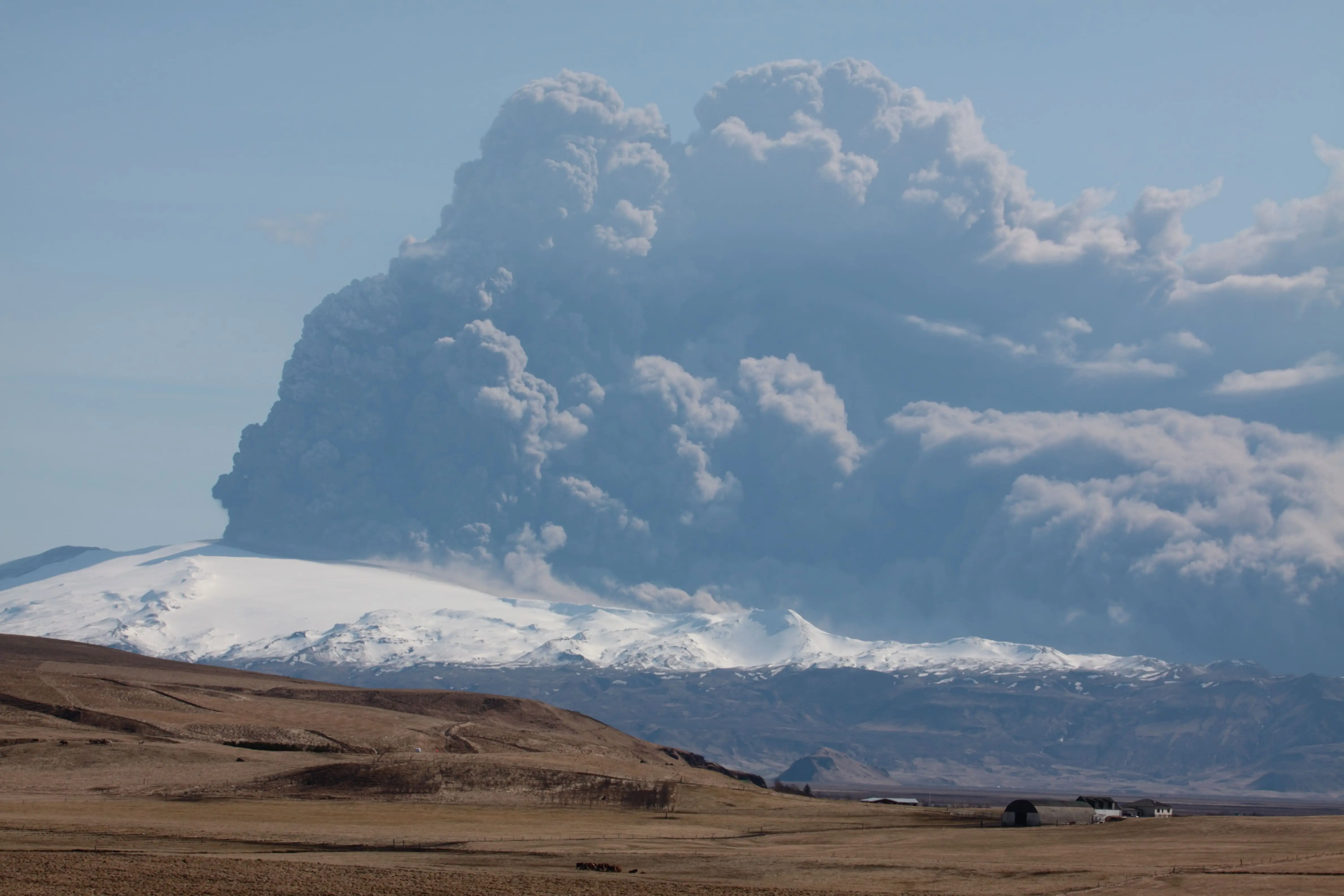
The 2010 Eyjafjallajökull eruption grounded European air travel for six days, cancelling over 100,000 flights and stranding around 10 million passengers.
The Reykjanes Peninsula has now produced 12 eruptions since March 2021, after 800 years of silence — the most recent ended 5 August 2025.
About 90% of Icelandic homes are heated geothermally, and the country generates almost all its electricity from renewable sources.
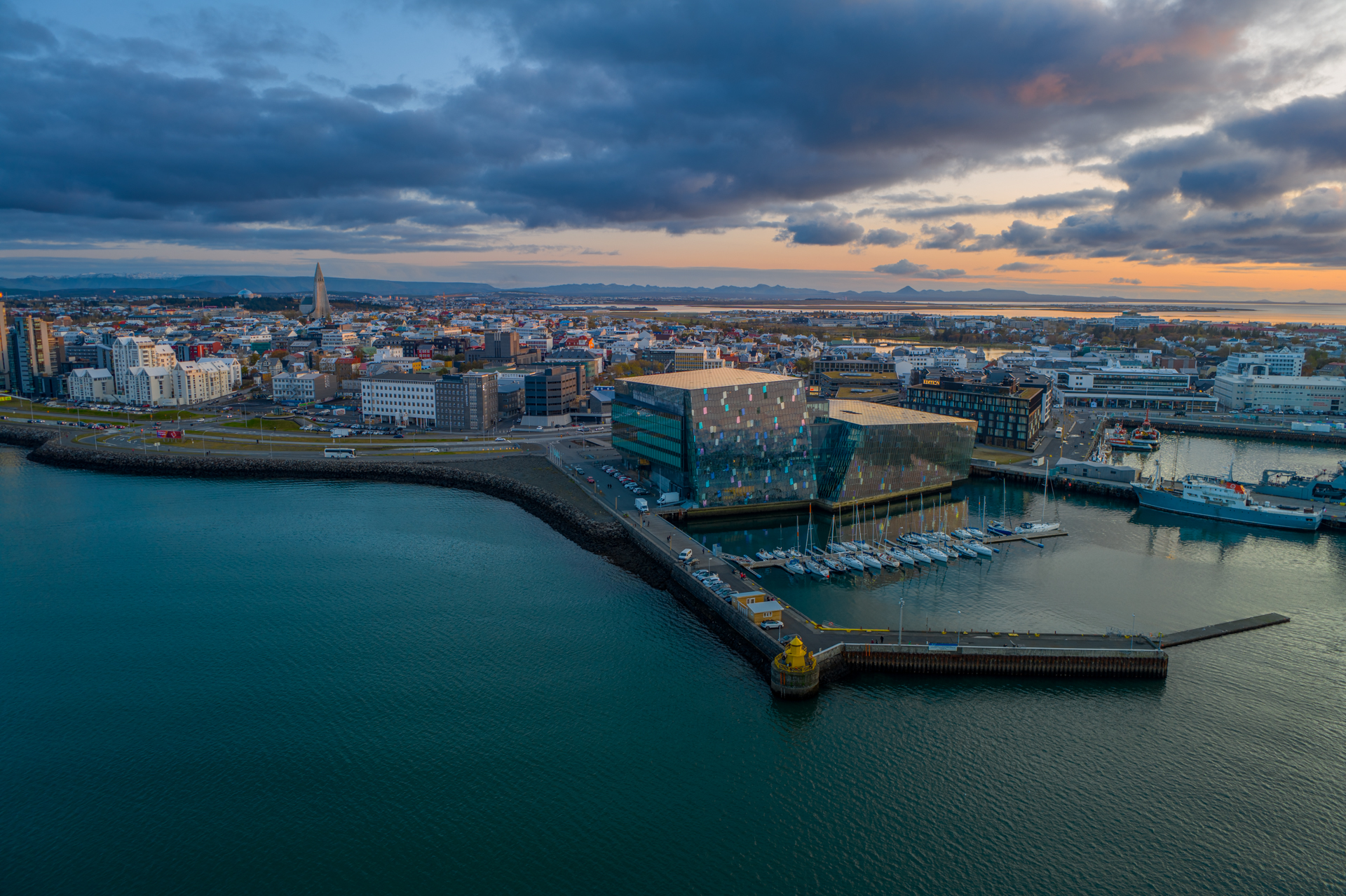
You can experience Iceland's volcanoes safely indoors at Volcano Express inside Harpa Concert Hall in central Reykjavík.
Iceland is the most volcanically active country on Earth. It sits directly on the Mid-Atlantic Ridge, where the Eurasian and North American plates pull apart, and over a deep mantle hotspot — a rare double engine that makes the island home to 32 active volcanic systems, the most concentrated zone of active volcanism anywhere on Earth.
To have Iceland's volcanoes explained properly is to follow a single thread of heat: from the spreading seam of the ocean floor, up through glaciers and fissure fields, and finally into the hot-water pipes running beneath Reykjavík's streets. Even the capital's name remembers it — Reykjavík means "smoky bay," chosen more than 1,100 years ago by settlers who saw steam drifting off the hot springs. Around 130 volcanic peaks dot an island only the size of Portugal, and the official Catalogue of Icelandic Volcanoes documents each of these systems and their eruption histories — on average, an eruption breaks out somewhere in the country every four to five years. What follows is why Iceland burns, the many ways it erupts, how it builds new land straight out of the sea, and how a nation turned all that danger into clean power.
Why does Iceland have so many volcanoes?
Beneath every volcano is the same engine: heat left over from the planet's birth, pulsing outward from the core and stirring slow currents through the mantle. That heat melts rock into magma, which collects in chambers underground until the pressure cracks the surface open — the Earth's exhale. Some eruptions explode with violent force; others release their energy gently, as lava spreading and cooling across the land.
What makes Iceland exceptional is where this happens. The island straddles the Mid-Atlantic Ridge, the vast undersea mountain range where the North American and Eurasian tectonic plates drift apart at roughly two centimetres a year — about the speed your fingernails grow. Almost everywhere else on Earth that boundary lies hidden thousands of metres below the waves.
In Iceland you can stand inside it. At Þingvellir, only forty-five minutes from Reykjavík, the rift rises clear above sea level, and you can walk through a valley where the two plates are visibly pulling apart. As they separate, fresh magma rises to fill the gap, and the island grows fractionally wider every year. The gap is so clean that at Silfra, a flooded fissure in the same rift, divers glide through crystal-clear glacial meltwater with a continental plate to either hand. Þingvellir is doubly remarkable: it is also where Icelanders founded one of the world's oldest parliaments in 930 AD, on ground that is quite literally splitting in two. This rift runs the entire length of the country, from the southwest tip to the north coast, so the whole island is, in effect, a torn seam in the planet's crust.
But a spreading ridge alone does not explain Iceland — the rest of the Mid-Atlantic Ridge is, after all, deep underwater. The island also sits over the Iceland hotspot, a mantle plume funnelling extra heat upward from far below the crust. It is this unusual pairing — a spreading plate boundary directly on top of a powerful mantle plume — that lifted Iceland above the ocean and keeps it so volcanically alive. Most volcanic regions get one driver or the other. Iceland got both, and that double engine is the burning heart behind everything else.
What are the main types of volcanic eruptions in Iceland?
Because Iceland combines a spreading ridge with a mantle plume, it produces nearly every style of eruption geologists recognise, which makes it one of the finest places on Earth to understand the types of volcanic eruptions as a whole. How an eruption behaves comes down to its magma and what it meets on the way out: thick, gas-rich magma tends to blast apart, runny basalt pours out in rivers, and any magma that hits water or ice turns suddenly violent. The range runs from near-gentle to nation-shaping — the Laki fissure eruption of 1783 poured out one of the largest lava flows in recorded history and loosed a sulphurous haze that killed roughly a fifth of all Icelanders and chilled summers across the Northern Hemisphere. Iceland serves up the entire spectrum.
Hekla
For centuries the Hekla volcano has been the most feared mountain in the country — the "queen of Icelandic mountains." In medieval Europe it was notorious as a gateway to Hell, where the souls of the damned were said to be dragged below. Hekla typically produces Vulcanian eruptions: short, sharp explosive blasts that throw ash and rock skyward before the activity settles into flowing lava. According to the Smithsonian Global Volcanism Program, it has erupted more than twenty times since 1104, and its fluorine-rich ash has repeatedly poisoned grazing livestock downwind; its tephra layers are so widespread that geologists use them as natural time-markers to date eruptions all across Iceland. Its most recent eruption, in 2000, gave barely any warning — exactly the trait that earned its dark reputation.
Eyjafjallajökull
No Icelandic volcano is better known abroad than Eyjafjallajökull. Its 2010 eruption began when magma rose through the glacier capping the volcano, met meltwater, and shattered into an enormous cloud of fine, abrasive ash — a phreatomagmatic eruption, the type produced when magma and water collide explosively. The ash spread across the continent and grounded aircraft for roughly six days, cancelling more than 100,000 flights, stranding an estimated ten million travellers, and costing the airline industry on the order of 1.7 billion US dollars in the largest peacetime shutdown of European airspace. For a deeper look at the eruption, see our piece on the 2010 Eyjafjallajökull eruption.
Grímsvötn
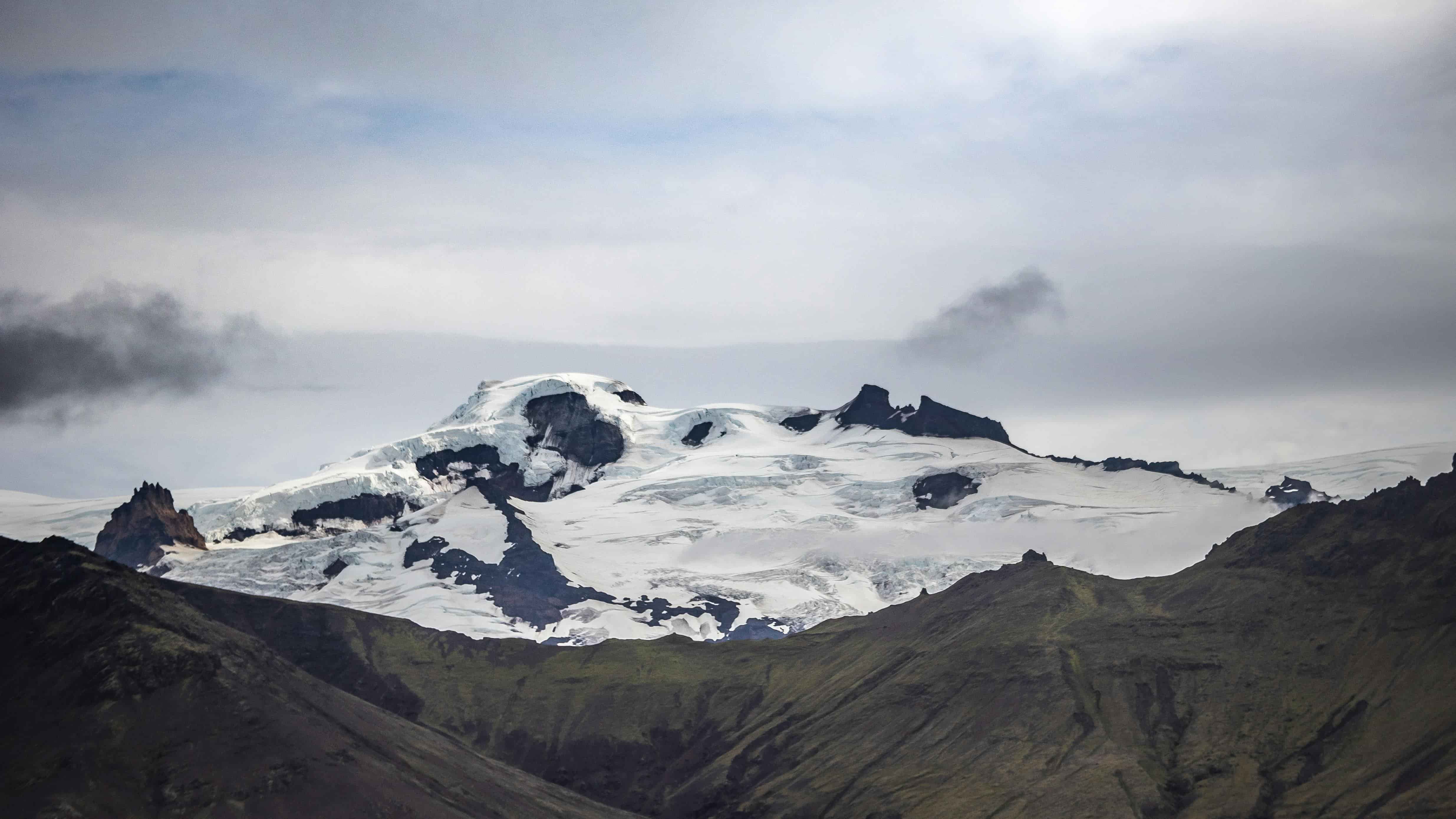
Buried beneath the Vatnajökull ice cap lies Grímsvötn, Iceland's most frequently erupting volcano. Because it sits under ice, its eruptions are usually subglacial: the heat melts the glacier from beneath, and steam and ash punch up through it. Its 2011 eruption threw an ash plume more than 20 kilometres into the sky, briefly surpassing Eyjafjallajökull's of the year before — though it cleared far more quickly and caused much less disruption.
Katla
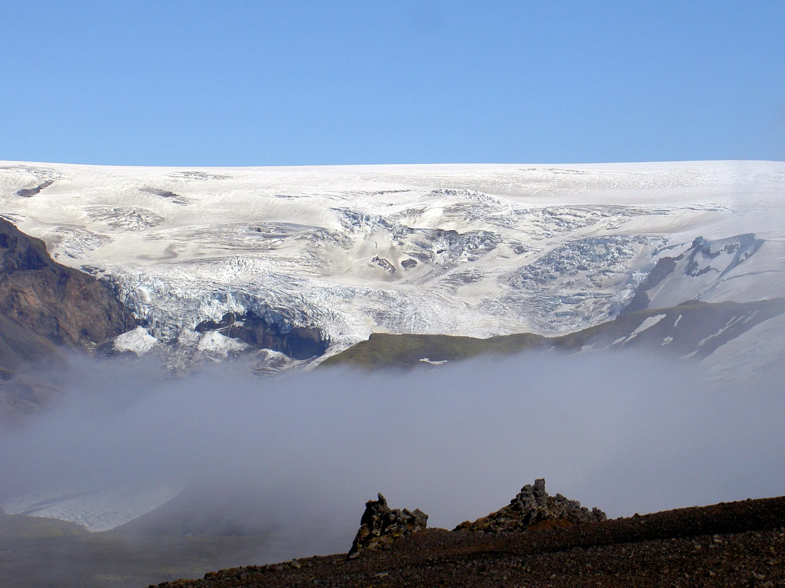
Just to the east, beneath the Mýrdalsjökull glacier, sleeps Katla, a far larger subglacial giant. Katla has historically erupted every few decades, and its last major eruption was in 1918. The unusually long quiet since then is watched closely, because a full Katla eruption can melt vast volumes of ice almost instantly — sending a wall of meltwater racing toward the coast.
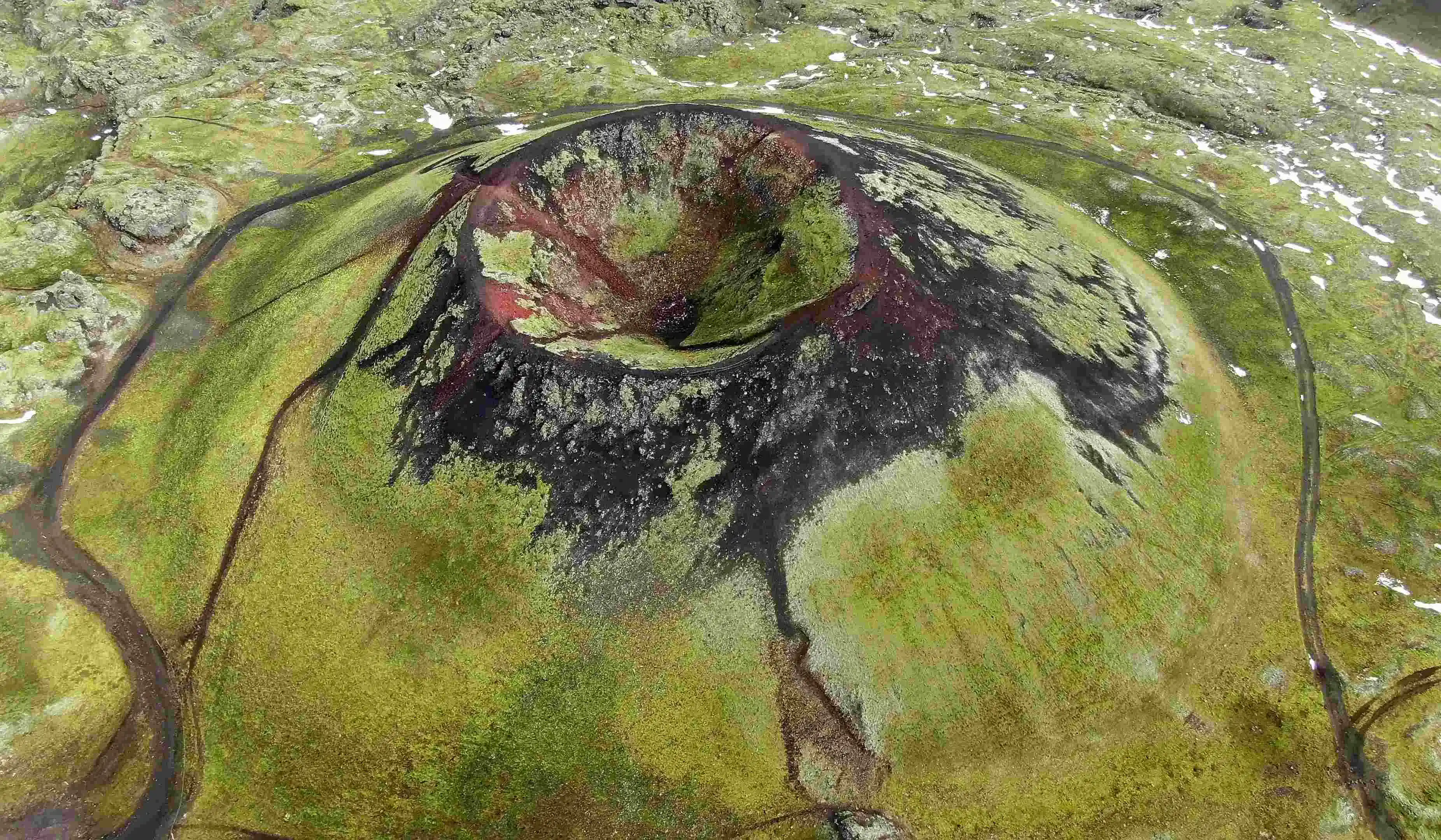
Askja
In the remote highlands, Askja produced one of the most consequential eruptions in the nation's history. In 1875 it unleashed a Plinian eruption — a towering, sustained column of ash and pumice, the most powerful explosive class, named for the Roman writer Pliny, who described the destruction of Vesuvius. Askja's ashfall poisoned farmland across eastern Iceland, and the hardship that followed helped drive thousands of Icelanders to emigrate to North America.
Jökulhlaup
Iceland's ice gives it a hazard most volcanic countries never face: the jökulhlaup, or glacial outburst flood. When an eruption melts the underside of a glacier, meltwater pools until it suddenly bursts free in a catastrophic torrent that carries ice blocks and boulders across the lowlands. At their peak, the floods from Grímsvötn and Katla have briefly rivalled the discharge of the world's largest rivers — which is why the Icelandic Meteorological Office keeps a real-time watch on every ice-capped volcano in the country, ready to close roads the moment the ground begins to stir.
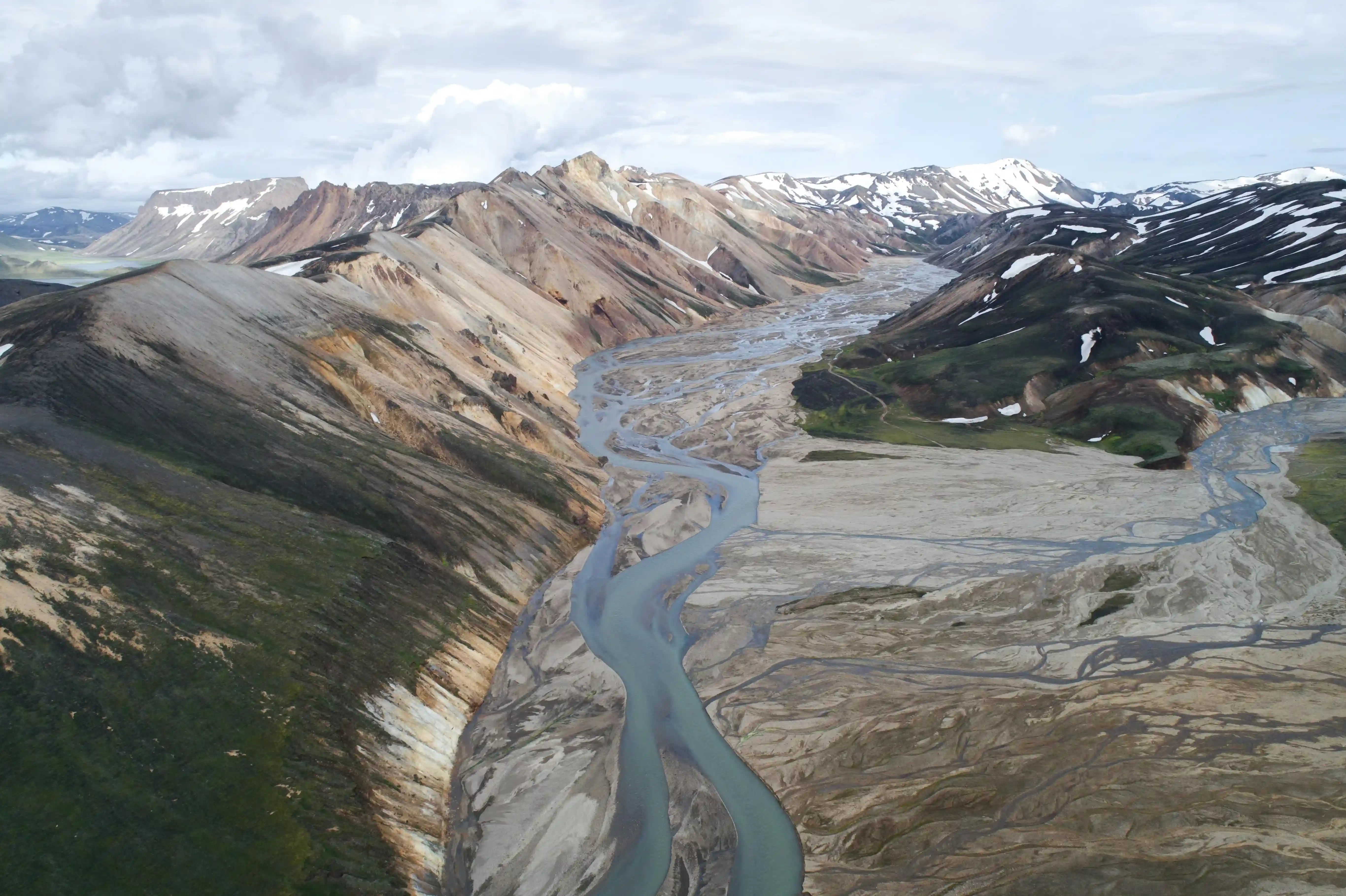
Reykjanes Peninsula
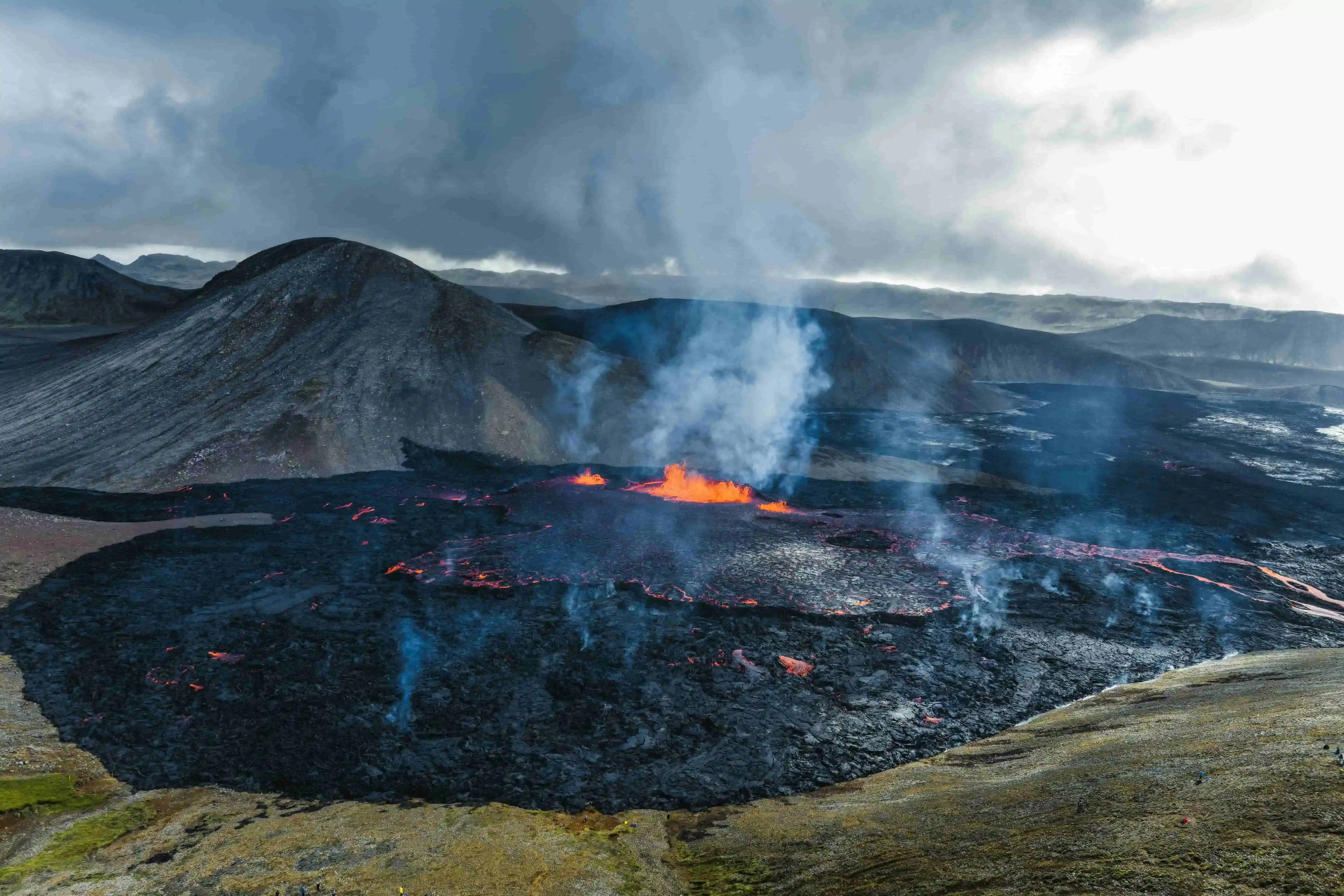
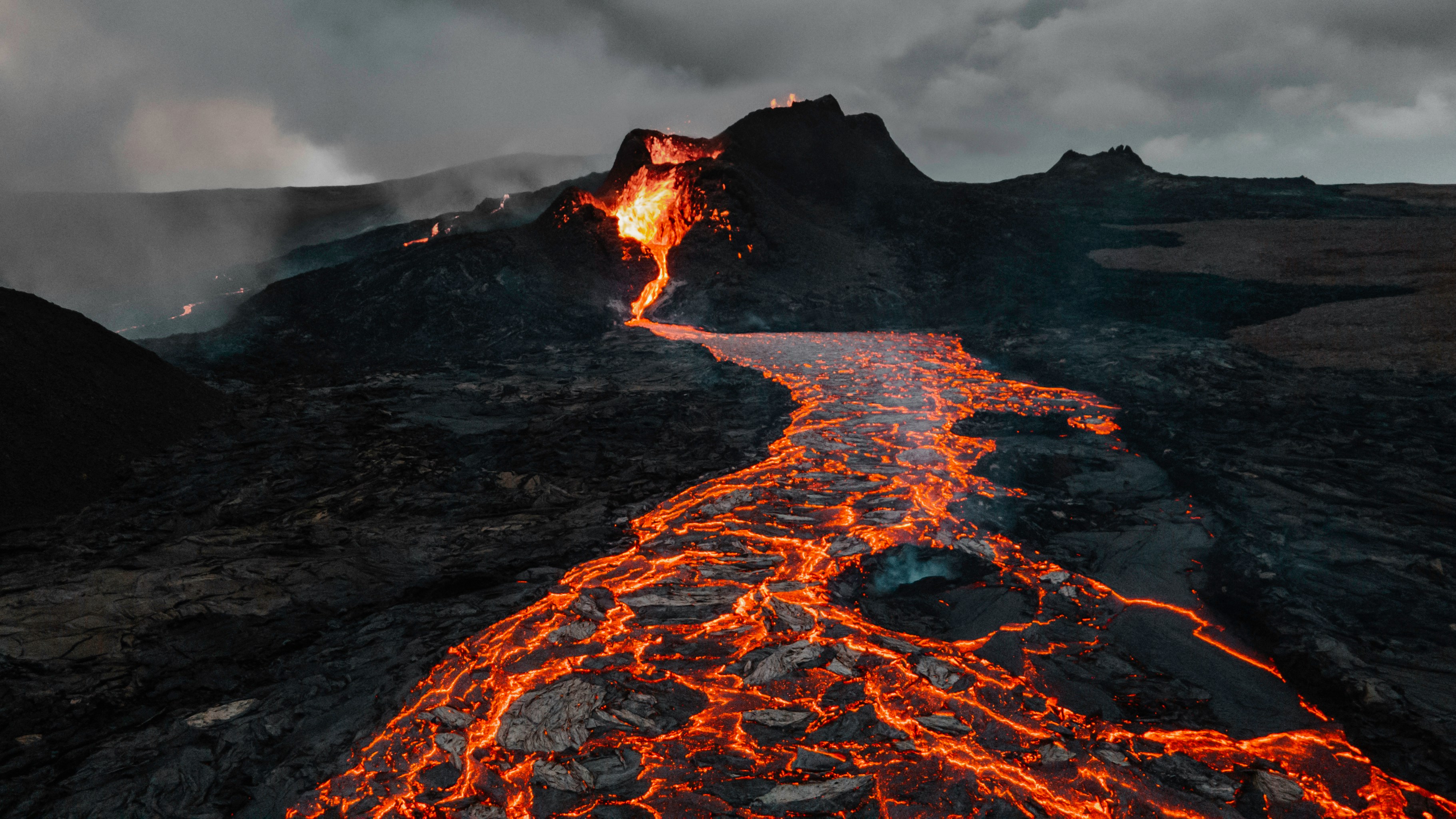
Not every eruption is a threat from above. On the Reykjanes Peninsula, just southwest of the capital, the ground reawakened in 2021 after roughly 800 years of silence. The Reykjanes Peninsula eruptions have been mostly Hawaiian in character — effusive, comparatively gentle fissures that crack open and spill steady rivers of fluid lava, at times feeding the rhythmic lava fountains of a Strombolian phase. As spectacular as the first eruptions were for onlookers, the sequence turned serious in late 2023, when the fishing town of Grindavík was evacuated as the ground tore open beneath it and lava threatened the Svartsengi power plant and the Blue Lagoon nearby. Engineers raised vast earthen barriers to divert the flows, and scientists believe this awakening could continue, on and off, for decades or even centuries.
As of May 2026, twelve eruptions have occurred on the peninsula since March 2021 — nine of them along the Sundhnúkur crater row since December 2023. The most recent ended on 5 August 2025, but researchers at Uppsala University have reported that as of March 2026 the magma volume beneath Sundhnúkur is back to pre-July 2025 levels, meaning another eruption is expected.
For all the eruptions Iceland reveals above ground, most of the planet's volcanism happens where nobody can see it. Around 80 percent of all eruptions occur beneath the oceans, along the same kind of mid-ocean ridges that run through Iceland, where lava meets cold seawater and freezes into strange, bulbous pillow shapes. Given enough time and enough eruptions, an undersea volcano can build all the way up to the surface — and just occasionally, a brand-new island is born in front of human witnesses.
That is precisely what happened with Surtsey. In November 1963, a fishing crew south of Iceland watched the sea begin to boil and an island climb out of the deep, with eruptions continuing until 1967. Surtsey, the island that emerged that winter, has been left almost untouched ever since: inscribed as a UNESCO World Heritage Site in 2008 and closed to the public, it is visited only by scientists who record, year after year, how a sterile mound of new rock comes to life. The first vascular plant took root in 1965; by 2004 researchers had logged some 60 species of higher plants alongside mosses, lichens, fungi, and growing seabird colonies. Its ecosystems are still forming, an unrepeatable laboratory of life gaining a foothold on raw ground — even as the North Atlantic slowly wears the young island back down.
Ten years later, the same forces struck a town. In 1973 a fissure split open on Heimaey, the only inhabited island of the Westman Islands, in the dead of night. The new volcano, later named Eldfell, or "fire mountain," sent the island's entire population of more than 5,000 people fleeing overnight aboard the local fishing fleet, and astonishingly, not a single life was lost during the evacuation. Lava bore down on the harbour, and islanders fought back by pumping seawater onto the advancing front to cool, slow, and steer it. By the time the eruption ended some five months later, Heimaey had grown by roughly two square kilometres and its harbour was better sheltered than before — and for years afterward the town drew heat from the cooling lava to warm its homes. Destruction and creation in one event.
Iceland is far from alone in this. In Hawaii, a mantle plume much like Iceland's builds gigantic shield volcanoes — broad, gently sloping mountains of fluid lava whose roots reach far beneath the Pacific. Across the world in Japan, an entire island arc was raised by a different mechanism, where one tectonic plate dives beneath another and melts, feeding a long chain of volcanoes. Wherever it occurs, the lesson is the one Iceland teaches best: volcanoes do not only destroy. They are how the Earth makes new ground.
How does Iceland use its volcanoes for clean energy?
Iceland's volcanoes are not only a hazard to be endured; they are an energy supply. Because the same heat that drives eruptions sits unusually close to the surface here, the country has built geothermal energy into the foundation of everyday life — and one of its most visible symbols is the Svartsengi power station on the Reykjanes Peninsula, a pioneering plant that was among the first in the world to generate electricity and supply hot water from the same geothermal field. The mineral-rich water flowing from Svartsengi is what created the famous Blue Lagoon beside it.
You can see the raw form of this process in a geyser. A geyser erupts where volcanic heat meets groundwater trapped in the rock: the water superheats under pressure until it flashes to steam and bursts upward, then the cycle resets. A geothermal power station does the same thing deliberately, and under control. Engineers drill wells as deep as 1,600 metres into the scorching rock, pump cold water down, and let it surge back up as steam and superheated water. That steam spins turbines to make clean electricity, while the leftover heat is passed through exchangers to warm a fresh supply of water.
That hot water then flows straight into the city. Through an extensive network of insulated pipelines, geothermally heated water circulates beneath Reykjavík to warm homes, schools, and the country's beloved swimming pools, before being pumped back underground to reheat and begin the cycle again. It is why roughly nine in ten Icelandic homes are heated without burning a drop of fuel; geothermal power supplies about a quarter of the nation's electricity and the great bulk of its heating, while hydropower covers most of the remainder, so Iceland produces very nearly all of its energy from renewable sources. Larger plants such as Hellisheiði, just outside the capital, rank among the biggest geothermal stations on Earth. The whole system is clean and renewable: no coal, no gas, no smoke — just the natural heat beneath everyone's feet, the very steam that named the "smoky bay" a thousand years ago. Icelanders live alongside their volcanoes, use them, and harness them, even knowing they can never truly tame them.
Where can you experience Iceland's volcanoes safely?
You can stand where all four of these stories meet — the ridge, the eruptions, the birth of land, and the geothermal grid — without ever leaving downtown Reykjavík. Volcano Express is at the Harpa Concert Hall on Floor K2, and opens with a 30-minute interactive pre-show built around the four chapters above, before sweeping you into a 10-minute cinematic motion-seat ride with real heat effects and actual footage from the Reykjanes eruptions, so you feel the lava as much as see it. The experience is fully indoors and runs year-round, needs no car, welcomes ages 4 and up, and starts every 15 minutes — find showtimes and book tickets at volcanoexpress.is.
Iceland sits on the Mid-Atlantic Ridge AND a deep mantle hotspot — the only place on Earth with both — producing 32 active volcanic systems and roughly 130 volcanic peaks on an island the size of Portugal.
An eruption occurs somewhere in Iceland on average every 4–5 years, the most concentrated active volcanism anywhere on Earth.
Iceland produces nearly every known eruption type — Hawaiian, Strombolian, Vulcanian, Plinian, and phreatomagmatic — making it one of the best places to study volcanoes globally.
The 2010 Eyjafjallajökull eruption grounded European air travel for six days, cancelling over 100,000 flights and stranding around 10 million passengers.
The Reykjanes Peninsula has now produced 12 eruptions since March 2021, after 800 years of silence — the most recent ended 5 August 2025.
About 90% of Icelandic homes are heated geothermally, and the country generates almost all its electricity from renewable sources.
You can experience Iceland's volcanoes safely indoors at Volcano Express inside Harpa Concert Hall in central Reykjavík.
Iceland is the most volcanically active country on Earth. It sits directly on the Mid-Atlantic Ridge, where the Eurasian and North American plates pull apart, and over a deep mantle hotspot — a rare double engine that makes the island home to 32 active volcanic systems, the most concentrated zone of active volcanism anywhere on Earth.
To have Iceland's volcanoes explained properly is to follow a single thread of heat: from the spreading seam of the ocean floor, up through glaciers and fissure fields, and finally into the hot-water pipes running beneath Reykjavík's streets. Even the capital's name remembers it — Reykjavík means "smoky bay," chosen more than 1,100 years ago by settlers who saw steam drifting off the hot springs. Around 130 volcanic peaks dot an island only the size of Portugal, and the official Catalogue of Icelandic Volcanoes documents each of these systems and their eruption histories — on average, an eruption breaks out somewhere in the country every four to five years. What follows is why Iceland burns, the many ways it erupts, how it builds new land straight out of the sea, and how a nation turned all that danger into clean power.
Why does Iceland have so many volcanoes?
Beneath every volcano is the same engine: heat left over from the planet's birth, pulsing outward from the core and stirring slow currents through the mantle. That heat melts rock into magma, which collects in chambers underground until the pressure cracks the surface open — the Earth's exhale. Some eruptions explode with violent force; others release their energy gently, as lava spreading and cooling across the land.
What makes Iceland exceptional is where this happens. The island straddles the Mid-Atlantic Ridge, the vast undersea mountain range where the North American and Eurasian tectonic plates drift apart at roughly two centimetres a year — about the speed your fingernails grow. Almost everywhere else on Earth that boundary lies hidden thousands of metres below the waves.
In Iceland you can stand inside it. At Þingvellir, only forty-five minutes from Reykjavík, the rift rises clear above sea level, and you can walk through a valley where the two plates are visibly pulling apart. As they separate, fresh magma rises to fill the gap, and the island grows fractionally wider every year. The gap is so clean that at Silfra, a flooded fissure in the same rift, divers glide through crystal-clear glacial meltwater with a continental plate to either hand. Þingvellir is doubly remarkable: it is also where Icelanders founded one of the world's oldest parliaments in 930 AD, on ground that is quite literally splitting in two. This rift runs the entire length of the country, from the southwest tip to the north coast, so the whole island is, in effect, a torn seam in the planet's crust.
But a spreading ridge alone does not explain Iceland — the rest of the Mid-Atlantic Ridge is, after all, deep underwater. The island also sits over the Iceland hotspot, a mantle plume funnelling extra heat upward from far below the crust. It is this unusual pairing — a spreading plate boundary directly on top of a powerful mantle plume — that lifted Iceland above the ocean and keeps it so volcanically alive. Most volcanic regions get one driver or the other. Iceland got both, and that double engine is the burning heart behind everything else.
What are the main types of volcanic eruptions in Iceland?
Because Iceland combines a spreading ridge with a mantle plume, it produces nearly every style of eruption geologists recognise, which makes it one of the finest places on Earth to understand the types of volcanic eruptions as a whole. How an eruption behaves comes down to its magma and what it meets on the way out: thick, gas-rich magma tends to blast apart, runny basalt pours out in rivers, and any magma that hits water or ice turns suddenly violent. The range runs from near-gentle to nation-shaping — the Laki fissure eruption of 1783 poured out one of the largest lava flows in recorded history and loosed a sulphurous haze that killed roughly a fifth of all Icelanders and chilled summers across the Northern Hemisphere. Iceland serves up the entire spectrum.
Hekla
For centuries the Hekla volcano has been the most feared mountain in the country — the "queen of Icelandic mountains." In medieval Europe it was notorious as a gateway to Hell, where the souls of the damned were said to be dragged below. Hekla typically produces Vulcanian eruptions: short, sharp explosive blasts that throw ash and rock skyward before the activity settles into flowing lava. According to the Smithsonian Global Volcanism Program, it has erupted more than twenty times since 1104, and its fluorine-rich ash has repeatedly poisoned grazing livestock downwind; its tephra layers are so widespread that geologists use them as natural time-markers to date eruptions all across Iceland. Its most recent eruption, in 2000, gave barely any warning — exactly the trait that earned its dark reputation.
Eyjafjallajökull
No Icelandic volcano is better known abroad than Eyjafjallajökull. Its 2010 eruption began when magma rose through the glacier capping the volcano, met meltwater, and shattered into an enormous cloud of fine, abrasive ash — a phreatomagmatic eruption, the type produced when magma and water collide explosively. The ash spread across the continent and grounded aircraft for roughly six days, cancelling more than 100,000 flights, stranding an estimated ten million travellers, and costing the airline industry on the order of 1.7 billion US dollars in the largest peacetime shutdown of European airspace. For a deeper look at the eruption, see our piece on the 2010 Eyjafjallajökull eruption.
Grímsvötn
Buried beneath the Vatnajökull ice cap lies Grímsvötn, Iceland's most frequently erupting volcano. Because it sits under ice, its eruptions are usually subglacial: the heat melts the glacier from beneath, and steam and ash punch up through it. Its 2011 eruption threw an ash plume more than 20 kilometres into the sky, briefly surpassing Eyjafjallajökull's of the year before — though it cleared far more quickly and caused much less disruption.
Katla
Just to the east, beneath the Mýrdalsjökull glacier, sleeps Katla, a far larger subglacial giant. Katla has historically erupted every few decades, and its last major eruption was in 1918. The unusually long quiet since then is watched closely, because a full Katla eruption can melt vast volumes of ice almost instantly — sending a wall of meltwater racing toward the coast.
Askja
In the remote highlands, Askja produced one of the most consequential eruptions in the nation's history. In 1875 it unleashed a Plinian eruption — a towering, sustained column of ash and pumice, the most powerful explosive class, named for the Roman writer Pliny, who described the destruction of Vesuvius. Askja's ashfall poisoned farmland across eastern Iceland, and the hardship that followed helped drive thousands of Icelanders to emigrate to North America.
Jökulhlaup
Iceland's ice gives it a hazard most volcanic countries never face: the jökulhlaup, or glacial outburst flood. When an eruption melts the underside of a glacier, meltwater pools until it suddenly bursts free in a catastrophic torrent that carries ice blocks and boulders across the lowlands. At their peak, the floods from Grímsvötn and Katla have briefly rivalled the discharge of the world's largest rivers — which is why the Icelandic Meteorological Office keeps a real-time watch on every ice-capped volcano in the country, ready to close roads the moment the ground begins to stir.
Reykjanes Peninsula
Not every eruption is a threat from above. On the Reykjanes Peninsula, just southwest of the capital, the ground reawakened in 2021 after roughly 800 years of silence. The Reykjanes Peninsula eruptions have been mostly Hawaiian in character — effusive, comparatively gentle fissures that crack open and spill steady rivers of fluid lava, at times feeding the rhythmic lava fountains of a Strombolian phase. As spectacular as the first eruptions were for onlookers, the sequence turned serious in late 2023, when the fishing town of Grindavík was evacuated as the ground tore open beneath it and lava threatened the Svartsengi power plant and the Blue Lagoon nearby. Engineers raised vast earthen barriers to divert the flows, and scientists believe this awakening could continue, on and off, for decades or even centuries.
As of May 2026, twelve eruptions have occurred on the peninsula since March 2021 — nine of them along the Sundhnúkur crater row since December 2023. The most recent ended on 5 August 2025, but researchers at Uppsala University have reported that as of March 2026 the magma volume beneath Sundhnúkur is back to pre-July 2025 levels, meaning another eruption is expected.
For all the eruptions Iceland reveals above ground, most of the planet's volcanism happens where nobody can see it. Around 80 percent of all eruptions occur beneath the oceans, along the same kind of mid-ocean ridges that run through Iceland, where lava meets cold seawater and freezes into strange, bulbous pillow shapes. Given enough time and enough eruptions, an undersea volcano can build all the way up to the surface — and just occasionally, a brand-new island is born in front of human witnesses.
That is precisely what happened with Surtsey. In November 1963, a fishing crew south of Iceland watched the sea begin to boil and an island climb out of the deep, with eruptions continuing until 1967. Surtsey, the island that emerged that winter, has been left almost untouched ever since: inscribed as a UNESCO World Heritage Site in 2008 and closed to the public, it is visited only by scientists who record, year after year, how a sterile mound of new rock comes to life. The first vascular plant took root in 1965; by 2004 researchers had logged some 60 species of higher plants alongside mosses, lichens, fungi, and growing seabird colonies. Its ecosystems are still forming, an unrepeatable laboratory of life gaining a foothold on raw ground — even as the North Atlantic slowly wears the young island back down.
Ten years later, the same forces struck a town. In 1973 a fissure split open on Heimaey, the only inhabited island of the Westman Islands, in the dead of night. The new volcano, later named Eldfell, or "fire mountain," sent the island's entire population of more than 5,000 people fleeing overnight aboard the local fishing fleet, and astonishingly, not a single life was lost during the evacuation. Lava bore down on the harbour, and islanders fought back by pumping seawater onto the advancing front to cool, slow, and steer it. By the time the eruption ended some five months later, Heimaey had grown by roughly two square kilometres and its harbour was better sheltered than before — and for years afterward the town drew heat from the cooling lava to warm its homes. Destruction and creation in one event.
Iceland is far from alone in this. In Hawaii, a mantle plume much like Iceland's builds gigantic shield volcanoes — broad, gently sloping mountains of fluid lava whose roots reach far beneath the Pacific. Across the world in Japan, an entire island arc was raised by a different mechanism, where one tectonic plate dives beneath another and melts, feeding a long chain of volcanoes. Wherever it occurs, the lesson is the one Iceland teaches best: volcanoes do not only destroy. They are how the Earth makes new ground.
How does Iceland use its volcanoes for clean energy?
Iceland's volcanoes are not only a hazard to be endured; they are an energy supply. Because the same heat that drives eruptions sits unusually close to the surface here, the country has built geothermal energy into the foundation of everyday life — and one of its most visible symbols is the Svartsengi power station on the Reykjanes Peninsula, a pioneering plant that was among the first in the world to generate electricity and supply hot water from the same geothermal field. The mineral-rich water flowing from Svartsengi is what created the famous Blue Lagoon beside it.
You can see the raw form of this process in a geyser. A geyser erupts where volcanic heat meets groundwater trapped in the rock: the water superheats under pressure until it flashes to steam and bursts upward, then the cycle resets. A geothermal power station does the same thing deliberately, and under control. Engineers drill wells as deep as 1,600 metres into the scorching rock, pump cold water down, and let it surge back up as steam and superheated water. That steam spins turbines to make clean electricity, while the leftover heat is passed through exchangers to warm a fresh supply of water.
That hot water then flows straight into the city. Through an extensive network of insulated pipelines, geothermally heated water circulates beneath Reykjavík to warm homes, schools, and the country's beloved swimming pools, before being pumped back underground to reheat and begin the cycle again. It is why roughly nine in ten Icelandic homes are heated without burning a drop of fuel; geothermal power supplies about a quarter of the nation's electricity and the great bulk of its heating, while hydropower covers most of the remainder, so Iceland produces very nearly all of its energy from renewable sources. Larger plants such as Hellisheiði, just outside the capital, rank among the biggest geothermal stations on Earth. The whole system is clean and renewable: no coal, no gas, no smoke — just the natural heat beneath everyone's feet, the very steam that named the "smoky bay" a thousand years ago. Icelanders live alongside their volcanoes, use them, and harness them, even knowing they can never truly tame them.
Where can you experience Iceland's volcanoes safely?
You can stand where all four of these stories meet — the ridge, the eruptions, the birth of land, and the geothermal grid — without ever leaving downtown Reykjavík. Volcano Express is at the Harpa Concert Hall on Floor K2, and opens with a 30-minute interactive pre-show built around the four chapters above, before sweeping you into a 10-minute cinematic motion-seat ride with real heat effects and actual footage from the Reykjanes eruptions, so you feel the lava as much as see it. The experience is fully indoors and runs year-round, needs no car, welcomes ages 4 and up, and starts every 15 minutes — find showtimes and book tickets at volcanoexpress.is.
Icelandic lava erupts at 1,000–1,200°C and shapes everything from Iceland's landscapes to its food culture. Discover the science and where to feel it in Reykjavík.
Erupting volcano update for Fagradalsfjall and the Reykjanes Peninsula. Find out which system is active in 2026, where to check live status, and how to visit safely.
Iceland eruption 2010: why Eyjafjallajökull shut down European airspace, how many flights were cancelled, and what the event tells us about Iceland's geology.