


Last updated: June 2026
Iceland geology is the product of two overlapping geological forces acting simultaneously: the Mid-Atlantic Ridge, where the North American and Eurasian tectonic plates diverge, and a deep mantle hotspot that amplifies volcanic activity far beyond what the ridge alone would generate. No other island on Earth sits at this specific intersection — which is why Iceland has 32 active volcanic systems, the world's most productive geothermal fields, Europe's largest glacier, and lava landscapes formed within living memory. This article explains how the science works and where it can be experienced directly.
Key takeaways
- Iceland sits astride the Mid-Atlantic Ridge, where tectonic plates diverge at approximately 2.5 cm per year — the only place this boundary rises above sea level
- Fagradalsfjall on the Reykjanes Peninsula produced effusive eruptions in 2021, 2022, 2023, and 2024 — among the most scientifically observed lava-forming events in modern history
- Iceland has 32 active volcanic systems — the highest density of any country of comparable area, according to the Icelandic Met Office
- Volcano Express at Harpa Concert Hall runs daily 10:00–20:00, year-round, providing an indoor cinematic experience of Iceland's volcanic geology from the Reykjavík waterfront
What is the geology of Iceland?
Iceland's geology is built on two geological processes operating in tandem: the divergence of the North American and Eurasian plates along the Mid-Atlantic Ridge, and a deep mantle hotspot that drives additional magma through the crust. Together, they have built the island through continuous volcanic eruption across approximately 16–18 million years.
The Mid-Atlantic Ridge bisects Iceland from southwest to northeast, producing a belt of rift valleys, fissure swarms, and central volcanic systems where the earth's crust is actively pulling apart. As the plates diverge, mantle material rises to fill the gap, partially melts under reduced pressure, and erupts at the surface as basaltic lava. Iceland's bedrock is therefore overwhelmingly volcanic in composition — the youngest formations concentrated in the central volcanic zones, older basaltic plateaus exposed in the east and northwest, forming a readable geological timeline across the landscape.
Geothermal heat — the thermal signature of shallow magma bodies heating groundwater — pervades most of the island. Iceland generates approximately 66% of its total primary energy from geothermal and hydropower combined, one of the highest renewable shares of any country in the world. This is not policy achievement; it is geological inheritance.
For anyone studying or visiting Iceland, the geological framework makes every landscape feature legible: dark lava fields, steaming vents, glaciers concealing erupting volcanoes, and walkable tectonic rifts all trace back to the same root causes at the plate boundary beneath the island.
Why is Iceland geologically unique?
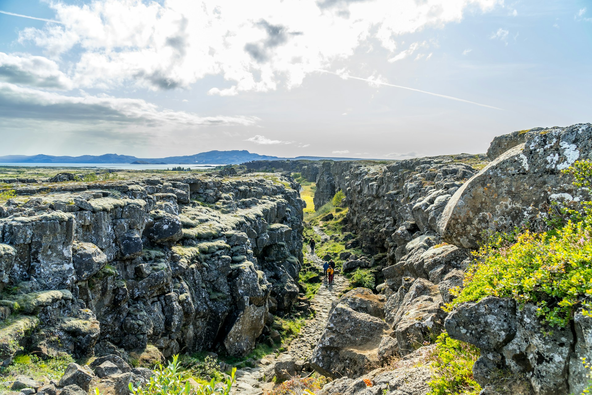
Iceland is geologically unique because it is the only location on Earth where the Mid-Atlantic Ridge is exposed above sea level, making active tectonic plate divergence directly observable — and at Þingvellir National Park, physically walkable. No other place allows a visitor to stand within the rift between two major tectonic plates on dry land and see the process of seafloor spreading replicated in a continental setting.
The second element of Iceland's uniqueness is the mantle hotspot — a column of anomalously hot mantle material beneath the North Atlantic. When this hotspot coincides with the Mid-Atlantic Ridge, volcanic productivity increases dramatically. Iceland's eruption frequency, lava volumes, geothermal heat output, and crustal thickness all exceed what the ridge alone would produce. The combination is what keeps Iceland above sea level despite lying on what would otherwise be a mid-ocean ridge.
The Reykjanes UNESCO Global Geopark — the peninsula southwest of Reykjavík — distils this uniqueness into a single accessible territory. The geopark designates the peninsula's geology as internationally significant because it preserves surface expressions of an active mid-ocean ridge: geothermal fields including Gunnuhver with its boiling mud pools, fissure swarms crossing the landscape, and lava fields produced by the Fagradalsfjall and Svartsengi volcanic systems since 2021. The peninsula remains in an active eruptive phase; current eruption status and access information are updated daily at almannavarnir.is.
"Iceland represents one of the most remarkable natural laboratories on Earth for the study of volcanic and tectonic processes — processes that elsewhere occur on the seafloor, inaccessible to direct observation." — Icelandic Met Office (en.vedur.is)
Iceland Geology Map: Understanding the Volcanic Zones
An Iceland geology map reveals four main volcanic zones running northeast–southwest across the island, each representing a different surface expression of the Mid-Atlantic Ridge and associated rift systems. These zones explain why geological features cluster where they do and how the island's rock types and landscapes vary across its surface.
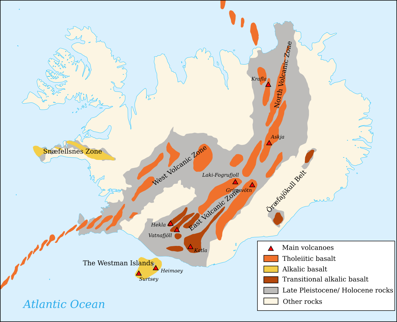
The Western Volcanic Zone
The Western Volcanic Zone (WVZ) includes Þingvellir National Park — the world's most visited tectonic geological site — and the Hengill volcanic system southwest of Reykjavík. At Þingvellir, the Almannagjá fissure is a surface rupture across the graben floor where the two plates have separated; visitors walk between continental plate margins on either side. The University of Iceland's Institute of Earth Sciences has tracked plate divergence here continuously for decades, recording measurable annual movement in the rock beneath the visitor trails.
The Eastern Volcanic Zone and Central Highlands
The Eastern Volcanic Zone (EVZ) is Iceland's most active volcanic belt, home to Hekla, Katla, Eyjafjallajökull, Grímsvötn, and the broad volcanic systems beneath Vatnajökull. The central highland interior — including Landmannalaugar within the Torfajökull system — exposes multicoloured rhyolite mountains alongside active geothermal vents, providing one of the world's most concentrated geology field exposures.
The Northern Volcanic Zone and Mývatn
The Northern Volcanic Zone (NVZ) extends from central Iceland to the north coast and produced the remarkable geology of the Mývatn lake district approximately 3,700 years ago. Shield volcano eruptions built the lake basin and the surrounding formations of pseudocraters — rootless cones formed when lava flowed over waterlogged ground — and pillow lava from subaqueous flows. The Námaskarð geothermal field adjacent to Mývatn provides some of Iceland's most dramatic surface geothermal activity: boiling sulphurous mud pools and steam vents rising from pale yellow deposits.
What type of rock is Iceland made of?
The geology of Iceland rocks and landscape is dominated by basalt — dark, dense, fine-grained igneous rock produced when low-viscosity basaltic magma erupts and cools rapidly at the surface. Approximately 90% of Iceland's bedrock is basalt, a direct product of the mantle-derived magma chemistry at divergent plate boundaries.

Basalt: Iceland's Dominant Rock
Basaltic magma has relatively low silica content (49–52% SiO₂) and flows easily, which is why Iceland's eruptions are predominantly effusive — lava spreads across the landscape rather than exploding upward. The characteristic dark lava fields, columnar basalt coastal cliffs, and flat-topped table mountains are all basaltic. Columnar basalt forms when thick flows cool slowly, contracting and fracturing into geometric hexagonal columns — as seen at Reynisfjara black sand beach and across Iceland's coastal headlands.
Rhyolite, Hyaloclastite, and Other Rock Types
Rhyolite — pale and silica-rich at 70–75% SiO₂ — forms through magmatic differentiation when basaltic melts interact with pre-existing crustal material. Landmannalaugar is Iceland's showcase for rhyolite geology: its mountains display ochre, green, red, and brown colours from mineral deposits cooling within the silica-rich rock, creating a visual contrast with the island's dominant black basalt that captures the full compositional range of Icelandic igneous rock.
Hyaloclastite is the third major rock type: glassy, fragmented basalt formed when lava erupts into water or beneath ice. Iceland's table mountains — called tuyas — are built entirely from hyaloclastite accumulated during subglacial eruptions in the last ice age. These formations are physical evidence that much of Iceland was simultaneously glaciated and volcanically active, with eruptions building upward through ice until they broke through as lava flows above the ice surface.
Iceland Volcano Geology: Hekla, Katla, and Fagradalsfjall
Iceland volcano geology encompasses 32 active volcanic systems with distinct eruptive histories, magma compositions, and hazard profiles — from the effusive shield-building eruptions of the Reykjanes Peninsula to the explosive subglacial systems beneath Vatnajökull. The most consequential systems in terms of historical impact and current scientific monitoring are Hekla, Katla, and the Reykjanes systems centred on Fagradalsfjall.
Hekla and Katla: Historically Active Systems
Hekla is one of Iceland's most internationally recognised volcanoes — a stratovolcano that has erupted more than 20 times since Iceland's settlement in the 9th century. Unlike Iceland's predominantly effusive shield volcanoes, Hekla produces mixed eruption styles: initial explosive phases have deposited ash layers as far as Scotland and Scandinavia in historical eruptions, followed by more effusive lava flows.
Katla, buried beneath Mýrdalsjökull glacier, is considered Iceland's most significant subglacial volcanic hazard. A major Katla eruption would generate a jökulhlaup — glacial outburst flood — through the Skaftá river system, with flow rates volcanologists estimate could temporarily exceed 200,000 m³/s. Katla last erupted in 1918 and shows elevated seismic and deformation signals monitored continuously by the Icelandic Met Office.
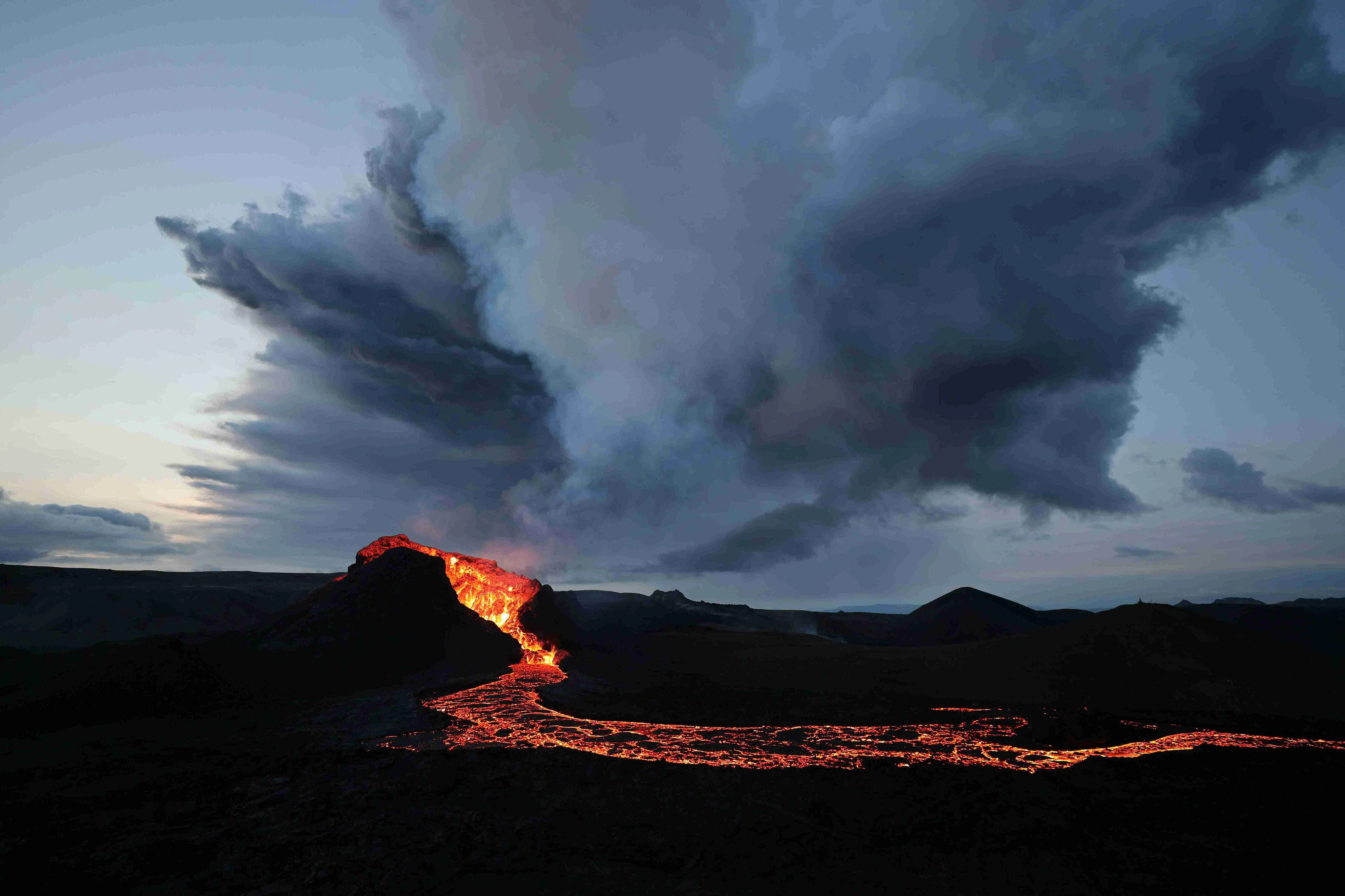
Fagradalsfjall transformed public understanding of Icelandic effusive volcanism. Its 2021, 2022, 2023, and 2024 eruptions were among the most extensively documented lava-forming events in history, allowing volcanologists and visitors to observe basaltic shield-building in real time. In 2026, the broader Reykjanes volcanic zone remains in the active eruptive phase that began in March 2021 after approximately 800 years of regional dormancy.
For a practical guide to visiting Iceland's volcanic sites with current safety information, see Iceland Volcano Tours: Geology, Routes & Safety Guide.
Geothermal Wonders: Geysir, Hot Springs, and Iceland's Energy Geology
Iceland's geothermal activity is the surface expression of shallow magma bodies heating groundwater, producing hot springs, geysers, mud pools, and fumaroles distributed across all four volcanic zones. The same geological process that creates these natural features supplies Iceland with most of its space heating and a substantial portion of its electricity.
Geysir — located in the Haukadalur geothermal field on the Golden Circle route — gave its Old Norse name to all geyser-type features worldwide. The original Geysir has been largely dormant for decades, but the nearby Strokkur erupts reliably every 5–10 minutes, reaching heights of 15–30 metres. The mechanism is purely geological: superheated water trapped in a constricted vent below surface pressure flashes explosively upward when conditions shift at the restriction point.
Iceland's geothermal pools are similarly direct expressions of the geology beneath the island. Laugardalslaug in Reykjavík's Laugardalur valley draws water from the geothermal field beneath the capital — the same system that has heated Reykjavík's homes through district heating since the 1930s. Visiting a Reykjavík geothermal pool is not a spa experience built around geology; it is the geology, accessed directly through a tap.
Glacial Geology: Where Ice Meets Active Volcanoes
Iceland's glacial geology is the consequence of volcanic systems erupting beneath extensive ice caps, producing subglacial lakes, explosive phreatomagmatic eruptions, and the catastrophic jökulhlaup floods that have periodically reshaped entire river valleys within recorded history. The interaction of magma and ice creates hazards and landforms unique to Iceland's dual geological identity.
Vatnajökull — Europe's largest glacier at approximately 8,300 km² — covers several of Iceland's most active volcanic centers, including Bárðarbunga, Grímsvötn, and Öræfajökull (Iceland's highest peak at 2,110 m). When a subglacial eruption melts ice from below, meltwater accumulates in a subglacial lake until hydrostatic pressure forces the water beneath the glacier margin in a sudden flood. The Skaftá river has experienced multiple such events from the Grímsvötn system; the 1996 Gjálp eruption generated a flood peaking at an estimated 45,000 m³/s and destroyed a major Ring Road bridge within hours.
The glacial geology record is preserved in the ice itself: researchers at the University of Iceland have extracted ice cores from Vatnajökull and Langjökull containing volcanic ash layers from Icelandic eruptions spanning centuries, providing precise chronological anchors for historical volcanic events.
Iceland's Geological Superlatives: Eldgjá, Surtsey, and Landmannalaugar
Iceland's geological record contains several events and features that are superlatives not merely at the national scale but globally — defining the upper bounds of what volcanic systems can produce and preserve. These sites give the widest context for Iceland's position in Earth science.
Eldgjá is the world's largest volcanic canyon, created by a fissure eruption in 934 AD that produced approximately 18–19 km³ of basaltic lava — the largest basaltic flood eruption in recorded human history. Sulphur dioxide emissions reached concentrations sufficient to trigger measurable climatic cooling across the Northern Hemisphere, documented in contemporaneous records from Europe and the Middle East. The canyon itself runs approximately 270 km through the south Iceland highlands.
Surtsey, which emerged from a submarine volcanic eruption off Iceland's south coast in November 1963 and is now a UNESCO World Heritage Site, represents a pristine geological baseline for understanding island-building volcanism and subsequent ecological colonisation. Surtsey's geology is still actively monitored and studied because it offers a natural experiment available nowhere else.
Landmannalaugar in the central highlands captures Icelandic geological variety in a single valley: rhyolite mountains in vivid mineral colour, obsidian lava flows, active geothermal vents, and basaltic lava fields from multiple eruption periods — all accessible from a single hiking base camp. For geology students and field researchers, it is one of Iceland's most information-dense geological landscapes.
For a guide to visiting these and other key geological sites, Best Geological Sites in Iceland: The Complete Guide covers location information and visitor access.
Experience Iceland's Geology Safely from Reykjavík
The geological forces described in this article are not historical records — they are active, ongoing, and in places temporarily inaccessible. Active lava fields require confirmed access; subglacial volcanic systems are monitored continuously; geothermal areas change from season to season. For visitors who want to understand the science before heading into the field — or who want to experience Iceland's volcanic geology regardless of road closures, weather, or field conditions — Reykjavík's waterfront provides a direct answer.
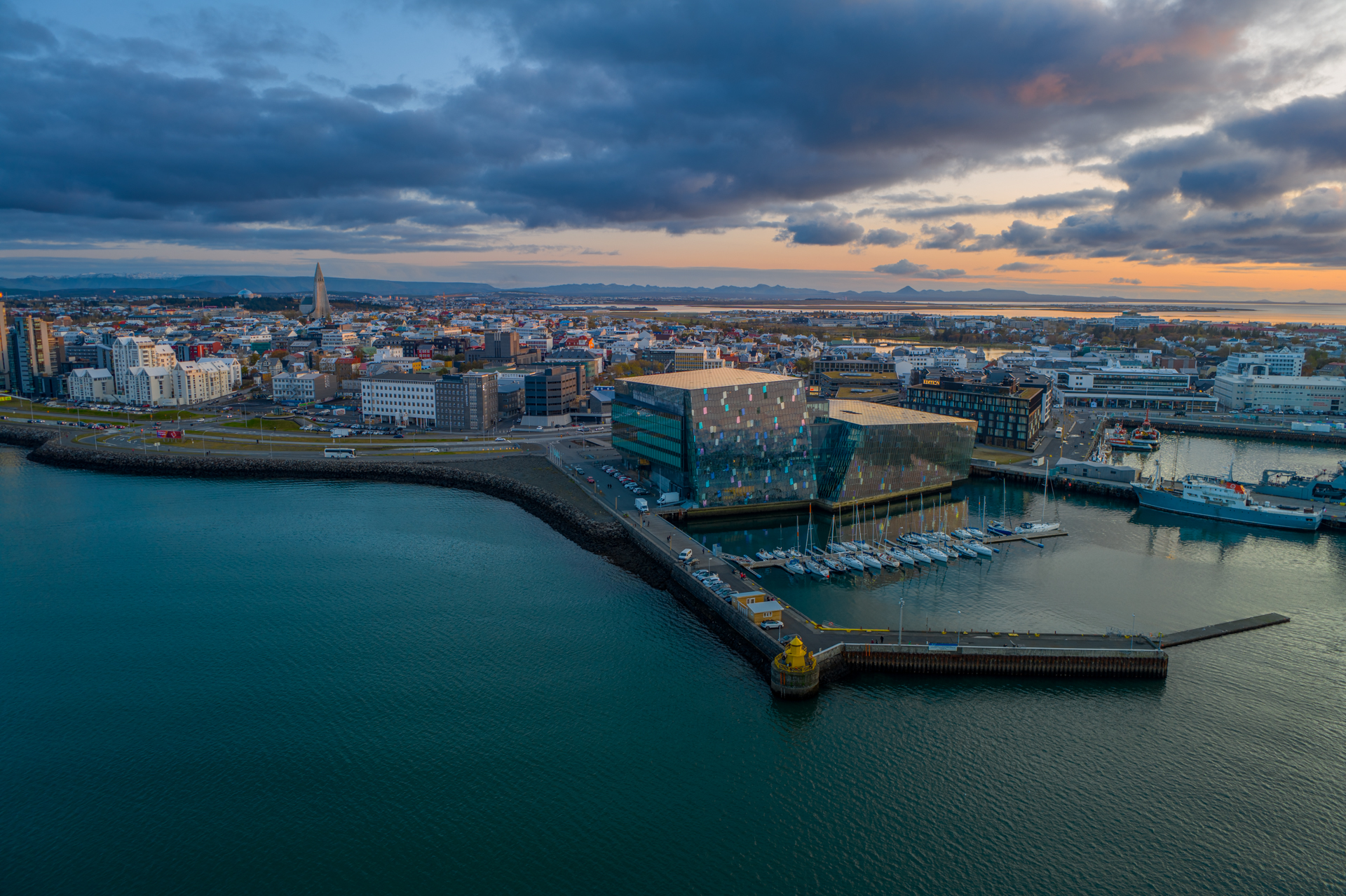
Volcano Express, inside Harpa Concert Hall on Reykjavík's waterfront at Austurbakki 2, is a cinematic motion-simulator volcanic experience built from footage of Iceland's actual 2021–2024 eruptions. Every ticket includes a 30-minute pre-show with a live earthquake monitor, an interactive Iceland eruption map, short geological films on lava formation and tectonic processes, and the Instacrater photo experience — followed by a 10-minute cinematic ride with dynamic motion seating and real heat effects that puts every concept in this article into immediate sensory context. Shows run every 15 minutes, daily 10:00–20:00, year-round and weather-independent. Suitable for ages 4 and up.

Whether planning an iceland geology tour across the volcanic zones or arriving in Reykjavík without a field itinerary, the island's geological story is best understood before stepping into the landscape. Volcano Express at Harpa runs every day of the year — the science beneath Iceland's surface does not take days off, and neither does the experience.
In this guide
- Best Geological Sites in Iceland: The Complete Guide
- Discover Iceland’s geothermal wonders and volcanic fields
- Explore Iceland's Top Volcano and Lava Experiences
- Eyjafjallajökull's impact on Iceland and beyond
- FAQs about Iceland’s volcanoes: Eruptions, tours, and safety tips
- Fire & Ice: When Volcanoes Erupt Beneath Glaciers
- How Hot Is Lava? The Science Behind an Icelandic Eruption
- How Volcanoes Are Connected to Icelandic Folklore
- Iceland Volcano Eruption 2010: Eyjafjallajökull Explained
- Iceland Volcano Tours: Geology, Routes & Safety Guide
- Iceland's Volcanoes Explained: Geology, Eruptions & Geothermal Power
- Inside Iceland’s Deadliest Eruptions | Volcano Tours Iceland
- Is Reykjavik Safe from Volcanoes? The Capital's Geology
- Is Thingvellir National Park a Volcano?
- Laki: The Eruption That Changed Global History
- Magma vs. Lava: The Science Of the Flow
- Tectonic Plates Iceland: Why the Island Is Pulling Apart
- Volcano Tours in Iceland: Explore Epic Lava Caves & Tunnels
- What Is Good Weather in Iceland? A Local's Guide
Last updated: June 2026
Iceland geology is the product of two overlapping geological forces acting simultaneously: the Mid-Atlantic Ridge, where the North American and Eurasian tectonic plates diverge, and a deep mantle hotspot that amplifies volcanic activity far beyond what the ridge alone would generate. No other island on Earth sits at this specific intersection — which is why Iceland has 32 active volcanic systems, the world's most productive geothermal fields, Europe's largest glacier, and lava landscapes formed within living memory. This article explains how the science works and where it can be experienced directly.
Key takeaways
- Iceland sits astride the Mid-Atlantic Ridge, where tectonic plates diverge at approximately 2.5 cm per year — the only place this boundary rises above sea level
- Fagradalsfjall on the Reykjanes Peninsula produced effusive eruptions in 2021, 2022, 2023, and 2024 — among the most scientifically observed lava-forming events in modern history
- Iceland has 32 active volcanic systems — the highest density of any country of comparable area, according to the Icelandic Met Office
- Volcano Express at Harpa Concert Hall runs daily 10:00–20:00, year-round, providing an indoor cinematic experience of Iceland's volcanic geology from the Reykjavík waterfront
What is the geology of Iceland?
Iceland's geology is built on two geological processes operating in tandem: the divergence of the North American and Eurasian plates along the Mid-Atlantic Ridge, and a deep mantle hotspot that drives additional magma through the crust. Together, they have built the island through continuous volcanic eruption across approximately 16–18 million years.
The Mid-Atlantic Ridge bisects Iceland from southwest to northeast, producing a belt of rift valleys, fissure swarms, and central volcanic systems where the earth's crust is actively pulling apart. As the plates diverge, mantle material rises to fill the gap, partially melts under reduced pressure, and erupts at the surface as basaltic lava. Iceland's bedrock is therefore overwhelmingly volcanic in composition — the youngest formations concentrated in the central volcanic zones, older basaltic plateaus exposed in the east and northwest, forming a readable geological timeline across the landscape.
Geothermal heat — the thermal signature of shallow magma bodies heating groundwater — pervades most of the island. Iceland generates approximately 66% of its total primary energy from geothermal and hydropower combined, one of the highest renewable shares of any country in the world. This is not policy achievement; it is geological inheritance.
For anyone studying or visiting Iceland, the geological framework makes every landscape feature legible: dark lava fields, steaming vents, glaciers concealing erupting volcanoes, and walkable tectonic rifts all trace back to the same root causes at the plate boundary beneath the island.
Why is Iceland geologically unique?
Iceland is geologically unique because it is the only location on Earth where the Mid-Atlantic Ridge is exposed above sea level, making active tectonic plate divergence directly observable — and at Þingvellir National Park, physically walkable. No other place allows a visitor to stand within the rift between two major tectonic plates on dry land and see the process of seafloor spreading replicated in a continental setting.
The second element of Iceland's uniqueness is the mantle hotspot — a column of anomalously hot mantle material beneath the North Atlantic. When this hotspot coincides with the Mid-Atlantic Ridge, volcanic productivity increases dramatically. Iceland's eruption frequency, lava volumes, geothermal heat output, and crustal thickness all exceed what the ridge alone would produce. The combination is what keeps Iceland above sea level despite lying on what would otherwise be a mid-ocean ridge.
The Reykjanes UNESCO Global Geopark — the peninsula southwest of Reykjavík — distils this uniqueness into a single accessible territory. The geopark designates the peninsula's geology as internationally significant because it preserves surface expressions of an active mid-ocean ridge: geothermal fields including Gunnuhver with its boiling mud pools, fissure swarms crossing the landscape, and lava fields produced by the Fagradalsfjall and Svartsengi volcanic systems since 2021. The peninsula remains in an active eruptive phase; current eruption status and access information are updated daily at almannavarnir.is.
"Iceland represents one of the most remarkable natural laboratories on Earth for the study of volcanic and tectonic processes — processes that elsewhere occur on the seafloor, inaccessible to direct observation." — Icelandic Met Office (en.vedur.is)
Iceland Geology Map: Understanding the Volcanic Zones
An Iceland geology map reveals four main volcanic zones running northeast–southwest across the island, each representing a different surface expression of the Mid-Atlantic Ridge and associated rift systems. These zones explain why geological features cluster where they do and how the island's rock types and landscapes vary across its surface.
The Western Volcanic Zone
The Western Volcanic Zone (WVZ) includes Þingvellir National Park — the world's most visited tectonic geological site — and the Hengill volcanic system southwest of Reykjavík. At Þingvellir, the Almannagjá fissure is a surface rupture across the graben floor where the two plates have separated; visitors walk between continental plate margins on either side. The University of Iceland's Institute of Earth Sciences has tracked plate divergence here continuously for decades, recording measurable annual movement in the rock beneath the visitor trails.
The Eastern Volcanic Zone and Central Highlands
The Eastern Volcanic Zone (EVZ) is Iceland's most active volcanic belt, home to Hekla, Katla, Eyjafjallajökull, Grímsvötn, and the broad volcanic systems beneath Vatnajökull. The central highland interior — including Landmannalaugar within the Torfajökull system — exposes multicoloured rhyolite mountains alongside active geothermal vents, providing one of the world's most concentrated geology field exposures.
The Northern Volcanic Zone and Mývatn
The Northern Volcanic Zone (NVZ) extends from central Iceland to the north coast and produced the remarkable geology of the Mývatn lake district approximately 3,700 years ago. Shield volcano eruptions built the lake basin and the surrounding formations of pseudocraters — rootless cones formed when lava flowed over waterlogged ground — and pillow lava from subaqueous flows. The Námaskarð geothermal field adjacent to Mývatn provides some of Iceland's most dramatic surface geothermal activity: boiling sulphurous mud pools and steam vents rising from pale yellow deposits.
What type of rock is Iceland made of?
The geology of Iceland rocks and landscape is dominated by basalt — dark, dense, fine-grained igneous rock produced when low-viscosity basaltic magma erupts and cools rapidly at the surface. Approximately 90% of Iceland's bedrock is basalt, a direct product of the mantle-derived magma chemistry at divergent plate boundaries.
Basalt: Iceland's Dominant Rock
Basaltic magma has relatively low silica content (49–52% SiO₂) and flows easily, which is why Iceland's eruptions are predominantly effusive — lava spreads across the landscape rather than exploding upward. The characteristic dark lava fields, columnar basalt coastal cliffs, and flat-topped table mountains are all basaltic. Columnar basalt forms when thick flows cool slowly, contracting and fracturing into geometric hexagonal columns — as seen at Reynisfjara black sand beach and across Iceland's coastal headlands.
Rhyolite, Hyaloclastite, and Other Rock Types
Rhyolite — pale and silica-rich at 70–75% SiO₂ — forms through magmatic differentiation when basaltic melts interact with pre-existing crustal material. Landmannalaugar is Iceland's showcase for rhyolite geology: its mountains display ochre, green, red, and brown colours from mineral deposits cooling within the silica-rich rock, creating a visual contrast with the island's dominant black basalt that captures the full compositional range of Icelandic igneous rock.
Hyaloclastite is the third major rock type: glassy, fragmented basalt formed when lava erupts into water or beneath ice. Iceland's table mountains — called tuyas — are built entirely from hyaloclastite accumulated during subglacial eruptions in the last ice age. These formations are physical evidence that much of Iceland was simultaneously glaciated and volcanically active, with eruptions building upward through ice until they broke through as lava flows above the ice surface.
Iceland Volcano Geology: Hekla, Katla, and Fagradalsfjall
Iceland volcano geology encompasses 32 active volcanic systems with distinct eruptive histories, magma compositions, and hazard profiles — from the effusive shield-building eruptions of the Reykjanes Peninsula to the explosive subglacial systems beneath Vatnajökull. The most consequential systems in terms of historical impact and current scientific monitoring are Hekla, Katla, and the Reykjanes systems centred on Fagradalsfjall.
Hekla and Katla: Historically Active Systems
Hekla is one of Iceland's most internationally recognised volcanoes — a stratovolcano that has erupted more than 20 times since Iceland's settlement in the 9th century. Unlike Iceland's predominantly effusive shield volcanoes, Hekla produces mixed eruption styles: initial explosive phases have deposited ash layers as far as Scotland and Scandinavia in historical eruptions, followed by more effusive lava flows.
Katla, buried beneath Mýrdalsjökull glacier, is considered Iceland's most significant subglacial volcanic hazard. A major Katla eruption would generate a jökulhlaup — glacial outburst flood — through the Skaftá river system, with flow rates volcanologists estimate could temporarily exceed 200,000 m³/s. Katla last erupted in 1918 and shows elevated seismic and deformation signals monitored continuously by the Icelandic Met Office.
Fagradalsfjall transformed public understanding of Icelandic effusive volcanism. Its 2021, 2022, 2023, and 2024 eruptions were among the most extensively documented lava-forming events in history, allowing volcanologists and visitors to observe basaltic shield-building in real time. In 2026, the broader Reykjanes volcanic zone remains in the active eruptive phase that began in March 2021 after approximately 800 years of regional dormancy.
For a practical guide to visiting Iceland's volcanic sites with current safety information, see Iceland Volcano Tours: Geology, Routes & Safety Guide.
Geothermal Wonders: Geysir, Hot Springs, and Iceland's Energy Geology
Iceland's geothermal activity is the surface expression of shallow magma bodies heating groundwater, producing hot springs, geysers, mud pools, and fumaroles distributed across all four volcanic zones. The same geological process that creates these natural features supplies Iceland with most of its space heating and a substantial portion of its electricity.
Geysir — located in the Haukadalur geothermal field on the Golden Circle route — gave its Old Norse name to all geyser-type features worldwide. The original Geysir has been largely dormant for decades, but the nearby Strokkur erupts reliably every 5–10 minutes, reaching heights of 15–30 metres. The mechanism is purely geological: superheated water trapped in a constricted vent below surface pressure flashes explosively upward when conditions shift at the restriction point.
Iceland's geothermal pools are similarly direct expressions of the geology beneath the island. Laugardalslaug in Reykjavík's Laugardalur valley draws water from the geothermal field beneath the capital — the same system that has heated Reykjavík's homes through district heating since the 1930s. Visiting a Reykjavík geothermal pool is not a spa experience built around geology; it is the geology, accessed directly through a tap.
Glacial Geology: Where Ice Meets Active Volcanoes
Iceland's glacial geology is the consequence of volcanic systems erupting beneath extensive ice caps, producing subglacial lakes, explosive phreatomagmatic eruptions, and the catastrophic jökulhlaup floods that have periodically reshaped entire river valleys within recorded history. The interaction of magma and ice creates hazards and landforms unique to Iceland's dual geological identity.
Vatnajökull — Europe's largest glacier at approximately 8,300 km² — covers several of Iceland's most active volcanic centers, including Bárðarbunga, Grímsvötn, and Öræfajökull (Iceland's highest peak at 2,110 m). When a subglacial eruption melts ice from below, meltwater accumulates in a subglacial lake until hydrostatic pressure forces the water beneath the glacier margin in a sudden flood. The Skaftá river has experienced multiple such events from the Grímsvötn system; the 1996 Gjálp eruption generated a flood peaking at an estimated 45,000 m³/s and destroyed a major Ring Road bridge within hours.
The glacial geology record is preserved in the ice itself: researchers at the University of Iceland have extracted ice cores from Vatnajökull and Langjökull containing volcanic ash layers from Icelandic eruptions spanning centuries, providing precise chronological anchors for historical volcanic events.
Iceland's Geological Superlatives: Eldgjá, Surtsey, and Landmannalaugar
Iceland's geological record contains several events and features that are superlatives not merely at the national scale but globally — defining the upper bounds of what volcanic systems can produce and preserve. These sites give the widest context for Iceland's position in Earth science.
Eldgjá is the world's largest volcanic canyon, created by a fissure eruption in 934 AD that produced approximately 18–19 km³ of basaltic lava — the largest basaltic flood eruption in recorded human history. Sulphur dioxide emissions reached concentrations sufficient to trigger measurable climatic cooling across the Northern Hemisphere, documented in contemporaneous records from Europe and the Middle East. The canyon itself runs approximately 270 km through the south Iceland highlands.
Surtsey, which emerged from a submarine volcanic eruption off Iceland's south coast in November 1963 and is now a UNESCO World Heritage Site, represents a pristine geological baseline for understanding island-building volcanism and subsequent ecological colonisation. Surtsey's geology is still actively monitored and studied because it offers a natural experiment available nowhere else.
Landmannalaugar in the central highlands captures Icelandic geological variety in a single valley: rhyolite mountains in vivid mineral colour, obsidian lava flows, active geothermal vents, and basaltic lava fields from multiple eruption periods — all accessible from a single hiking base camp. For geology students and field researchers, it is one of Iceland's most information-dense geological landscapes.
For a guide to visiting these and other key geological sites, Best Geological Sites in Iceland: The Complete Guide covers location information and visitor access.
Experience Iceland's Geology Safely from Reykjavík
The geological forces described in this article are not historical records — they are active, ongoing, and in places temporarily inaccessible. Active lava fields require confirmed access; subglacial volcanic systems are monitored continuously; geothermal areas change from season to season. For visitors who want to understand the science before heading into the field — or who want to experience Iceland's volcanic geology regardless of road closures, weather, or field conditions — Reykjavík's waterfront provides a direct answer.
Volcano Express, inside Harpa Concert Hall on Reykjavík's waterfront at Austurbakki 2, is a cinematic motion-simulator volcanic experience built from footage of Iceland's actual 2021–2024 eruptions. Every ticket includes a 30-minute pre-show with a live earthquake monitor, an interactive Iceland eruption map, short geological films on lava formation and tectonic processes, and the Instacrater photo experience — followed by a 10-minute cinematic ride with dynamic motion seating and real heat effects that puts every concept in this article into immediate sensory context. Shows run every 15 minutes, daily 10:00–20:00, year-round and weather-independent. Suitable for ages 4 and up.
Whether planning an iceland geology tour across the volcanic zones or arriving in Reykjavík without a field itinerary, the island's geological story is best understood before stepping into the landscape. Volcano Express at Harpa runs every day of the year — the science beneath Iceland's surface does not take days off, and neither does the experience.
In this guide
- Best Geological Sites in Iceland: The Complete Guide
- Discover Iceland’s geothermal wonders and volcanic fields
- Explore Iceland's Top Volcano and Lava Experiences
- Eyjafjallajökull's impact on Iceland and beyond
- FAQs about Iceland’s volcanoes: Eruptions, tours, and safety tips
- Fire & Ice: When Volcanoes Erupt Beneath Glaciers
- How Hot Is Lava? The Science Behind an Icelandic Eruption
- How Volcanoes Are Connected to Icelandic Folklore
- Iceland Volcano Eruption 2010: Eyjafjallajökull Explained
- Iceland Volcano Tours: Geology, Routes & Safety Guide
- Iceland's Volcanoes Explained: Geology, Eruptions & Geothermal Power
- Inside Iceland’s Deadliest Eruptions | Volcano Tours Iceland
- Is Reykjavik Safe from Volcanoes? The Capital's Geology
- Is Thingvellir National Park a Volcano?
- Laki: The Eruption That Changed Global History
- Magma vs. Lava: The Science Of the Flow
- Tectonic Plates Iceland: Why the Island Is Pulling Apart
- Volcano Tours in Iceland: Explore Epic Lava Caves & Tunnels
- What Is Good Weather in Iceland? A Local's Guide


.jpg)


