


Last updated: May 2026
Iceland tours focused on volcanic geology put visitors at one of Earth's most geologically active surfaces. Iceland sits simultaneously on the Mid-Atlantic Ridge and above a mantle hotspot — a dual energy source that drives 30 active volcanic systems across the island. This guide covers the geology behind what makes Iceland unique, which routes reach the most significant volcanic sites, and how to experience the country's geological story safely in 2026.
Key takeaways
- Iceland has recorded 247 volcanic eruptions since settlement in 874 AD, according to the Icelandic Met Office
- The Reykjanes Peninsula entered a new eruptive cycle in March 2021, producing multiple fissure eruptions at Fagradalsfjall — the most-visited active volcano site in Iceland's modern history
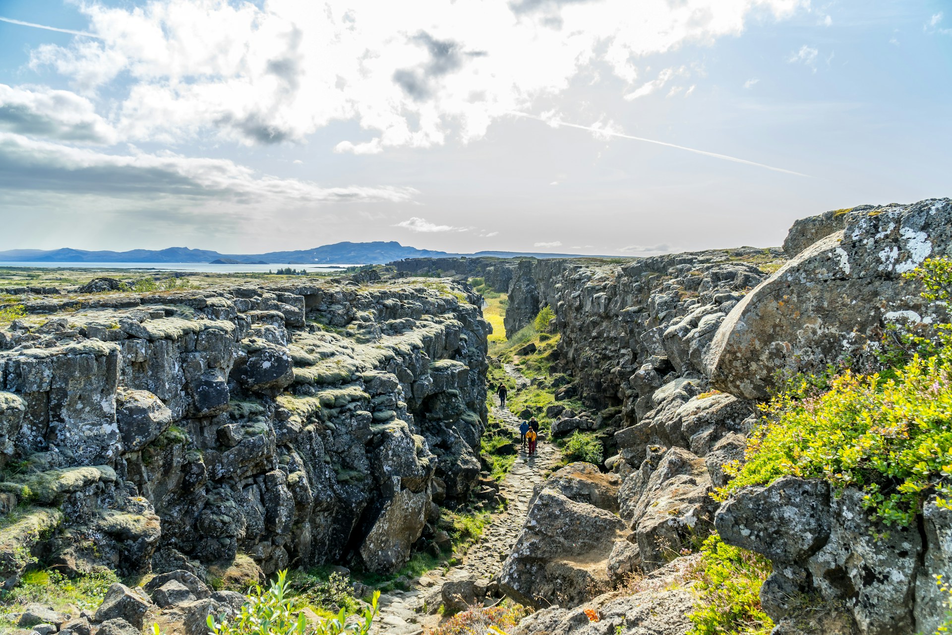
- Þingvellir National Park is a UNESCO World Heritage Site on the Mid-Atlantic Ridge where the two tectonic plates are directly walkable
- Eyjafjallajökull's 2010 eruption grounded over 100,000 flights across Europe, demonstrating Iceland's volcanic reach well beyond its own coastline
- Volcano Express at Harpa Concert Hall runs year-round, daily 10:00–20:00, with shows every 15 minutes, suitable for ages 4 and up
Why Iceland Has More Active Volcanoes Than Almost Any Country on Earth
Iceland's extraordinary volcanic activity stems from its unique double geology: the island sits on the Mid-Atlantic Ridge, where the Eurasian and North American tectonic plates diverge, and directly above a mantle hotspot that delivers independent heat from below. No other landmass on Earth sits at this specific intersection. The result is approximately 30 active volcanic systems — and a landscape that has been producing new surface material for at least 16 million years.
The Mid-Atlantic Ridge runs the full length of Iceland from southwest to northeast, visible most dramatically at Þingvellir National Park, where the rift valley sinks 40 metres below the surrounding plateau. Iceland has produced roughly one-third of all basaltic lava erupted on Earth's surface in the past 500 years. That figure comes from the University of Iceland's Institute of Earth Sciences and gives the scale of what visitors are walking across when they visit an Icelandic lava field.
For an in-depth account of one of Iceland's most historically significant volcanic systems, Uncover the fiery secrets of Hekla, Iceland's iconic volcano traces Hekla's eruption history from 1104 AD to the present day.
Iceland's Key Volcanic Zones
- Reykjanes Peninsula — the most active zone since 2021; home to Fagradalsfjall and the Svartsengi system; 45 minutes southwest of Reykjavík; designated Iceland's first UNESCO Global Geopark
- Eastern Volcanic Zone — contains Hekla (21 eruptions since 1104), Katla (subglacial, considered overdue), and Eyjafjallajökull (erupted 2010)
- Northern Volcanic Zone — centres on Mývatn lake district; pseudocraters, lava formations, and the Krafla caldera system
- Snæfellsnes Peninsula — Snæfellsjökull National Park contains a glacier-capped active stratovolcano; 2 hours northwest of Reykjavík
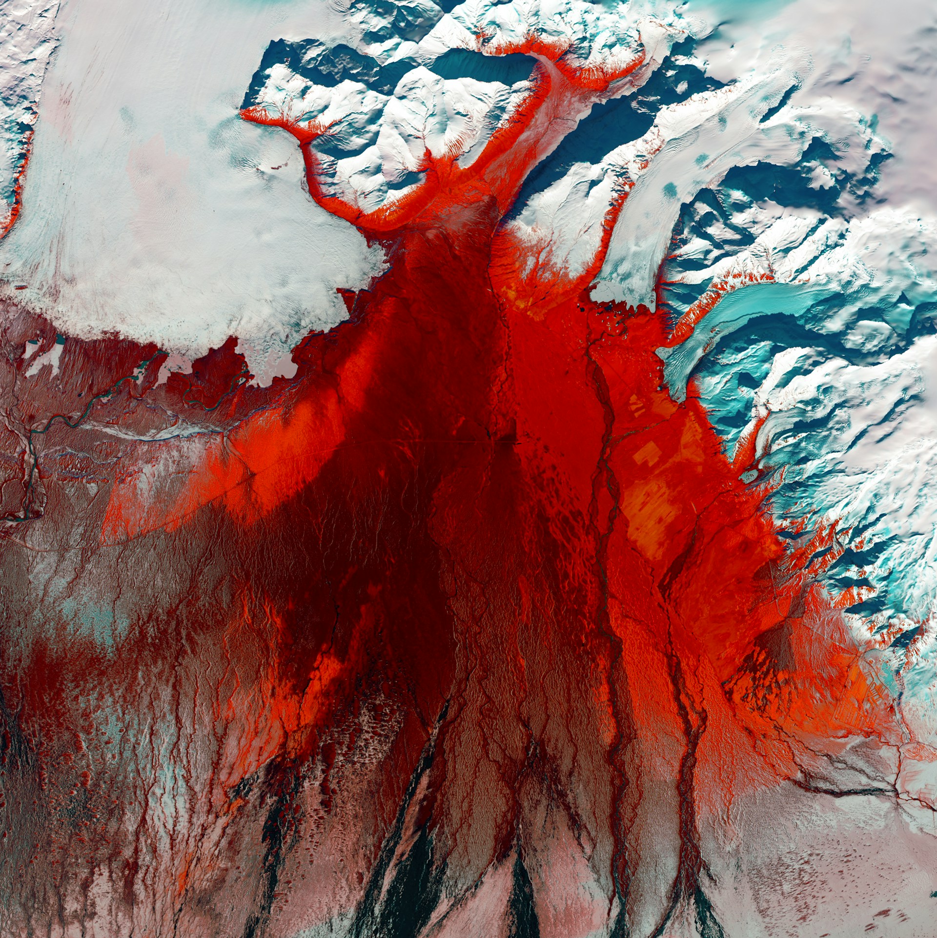
- Vatnajökull National Park — Europe's largest glacier sits atop multiple active subglacial volcanic systems; eruptions produce glacial outburst floods that have historically destroyed ring road bridges
What is the best month to go to Iceland?
The best month to visit Iceland for volcano touring is September or October: active lava sites remain fully accessible, northern lights become visible, and summer crowds thin out. June and July offer the midnight sun and the widest access to highland routes. February through March balance increasing daylight with strong aurora probability.
Iceland's geological tour season effectively runs all year, because Iceland's volcanic activity does not follow the tourist calendar. The Golden Circle, the Reykjanes Peninsula, and the South Coast waterfall route all operate in winter. Highland interior routes — including the on Floor K2 of Harpa Concert Hall, east-harbour-side Reykjavík Trail through Landmannalaugar to Þórsmörk — open in late June and close by early October, dependent on snow clearance. Northern lights tours operate September through March; the aurora forecast is published daily by the Icelandic Met Office at en.vedur.is.
SeasonKey FeatureVolcano Site AccessNorthern LightsJune–AugustMidnight sunFull, including highlandsNot visibleSeptember–OctoberAutumn colourFull, all sitesGoodNovember–JanuaryPolar nightPeninsula + South CoastPeak darknessFebruary–MarchLengthening daysPeninsula + South CoastGoodApril–MaySpring thawSouth Coast opens; highlands lateFading
What is the best Iceland tour?
The best Iceland tour for a first visit is a Golden Circle day trip — a 300 km self-drive or guided circuit covering Þingvellir National Park, the Geysir geothermal area, and Gullfoss waterfall — because it addresses all three of Iceland's defining natural forces in a single accessible day. Golden circle Iceland tours depart from Reykjavík year-round in self-drive, guided minibus, and private formats.
Þingvellir National Park is the geological anchor. The rift valley between the two tectonic plates is directly walkable, with the graben floor sitting 40 metres below the surrounding plateau — a physical record of 10,000 years of plate separation. The Geysir geothermal area contains Strokkur, which erupts to approximately 20 metres every 5–7 minutes; this is the geyser whose name gave the English language its word for the phenomenon. Gullfoss is a two-tiered glacial waterfall on the Hvítá river, fed by Langjökull glacier, dropping 32 metres into a narrow canyon.
Extending to the South Coast
Multi-day itineraries that add the South Coast (Suðurland) deliver Iceland's most geologically varied touring corridor. Seljalandsfoss — walkable behind the curtain — and Skógafoss — with 527 climbable steps to a ridge above the coastal plain — are glacial waterfalls fed by ice caps above Eyjafjallajökull and Mýrdalsjökull. Further east, Reynisfjara black sand beach sits beneath Reynisfjall cliffs of columnar basalt — the cooled interior of an old lava flow exposed by coastal erosion.
The Southeast: Vatnajökull and Jökulsárlón
Jökulsárlón Glacier Lagoon marks the end of the South Coast route. Icebergs calved from Breiðamerkurjökull — an outlet glacier of Vatnajökull — float through the lagoon and onto the adjacent Diamond Beach. Vatnajökull National Park surrounding the lagoon covers 14,141 km² and is a UNESCO World Heritage Site; beneath the ice, active volcanic systems produce subglacial eruptions capable of generating catastrophic meltwater floods. What looks like a scenic glacial landscape is, geologically, a volcano wearing a glacier as a lid.
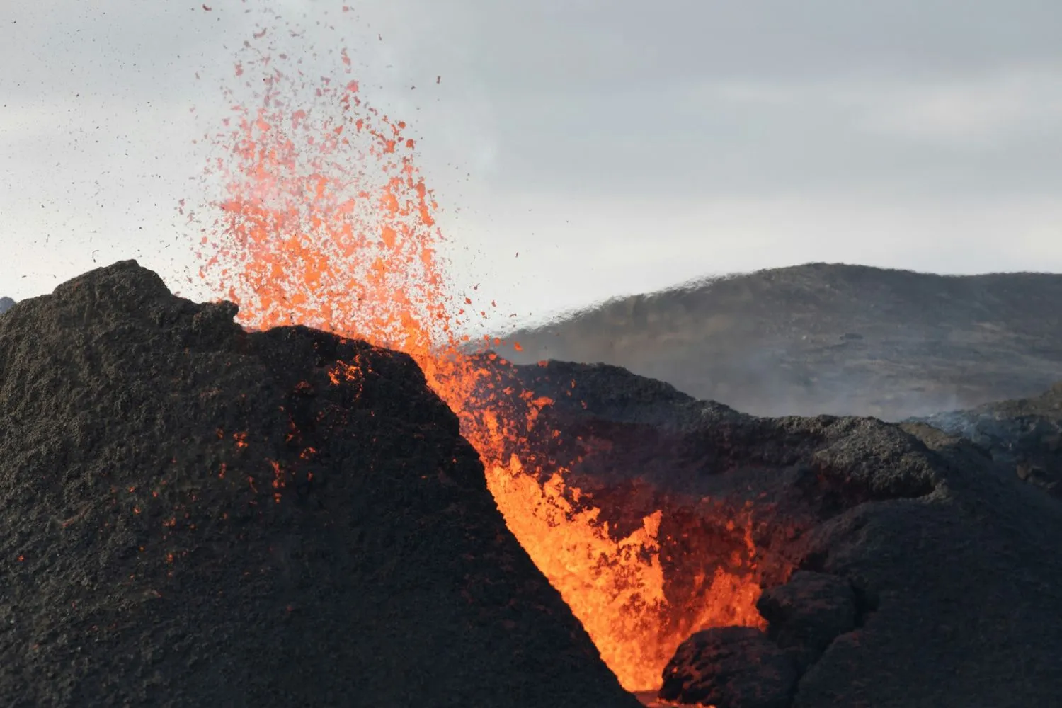
The Reykjanes Peninsula and Fagradalsfjall: Iceland's Accessible Active Zone
The Reykjanes Peninsula has produced multiple fissure eruptions since March 2021 at the Fagradalsfjall volcanic system and the adjacent Svartsengi system, making it the world's most visited active volcanic zone in recent years — and the one site competitors most frequently omit from Iceland tour guides.
Fagradalsfjall is a shield volcano that erupted in 2021, 2022, and 2023, with further eruptive activity continuing within the Svartsengi geothermal and volcanic system. The lava fields produced are among the youngest exposed surfaces on Earth. Access to active sites changes with each eruption event; road closures and safety perimeters are updated daily at almannavarnir.is.
The Blue Lagoon (Bláa Lónið) sits within this active zone and has temporarily closed multiple times since 2021. Travellers planning a Blue Lagoon visit should check bluelagoon.is for current operational status before travelling. The broader peninsula carries UNESCO Global Geopark designation, recognising its status as a globally significant section of exposed mid-ocean ridge geology. Walking across the Reykjanes Peninsula is, in the most literal sense, walking across a tectonic plate boundary that has been lifted above sea level.
What to be careful of in Iceland?
The primary safety risks on Iceland volcano tours are unpredictable weather, powerful and unpredictable coastal waves, volcanic gas concentrations near active lava, and unbridged river crossings in the highland interior. Each element of this list has caused fatalities among visitors and requires specific preparation.
Iceland's weather is not seasonal in the way visitors from temperate climates expect. A clear morning in August can become a 25 m/s wind event by afternoon. At coastal sites like Reynisfjara black sand beach, waves arrive without warning and kill visitors who stand too close to the water. Marked safe zones are present at high-risk beaches; the zones exist because the hazard is real.
Near active lava on the Reykjanes Peninsula, volcanic gas — primarily sulphur dioxide — reaches hazardous concentrations at ground level, particularly in still conditions. Wind direction determines safe approach angles, which is why guided tours are strongly recommended for any active lava field visit. Current volcanic hazard information is published daily at safetravel.is.
Practical safety checklist for Iceland tours:
- Check safetravel.is before every outdoor excursion, regardless of season
- Never drive F-roads (highland tracks) in a standard hire car
- Stay behind marked wave boundaries at all black sand beaches
- Download the 112 Iceland emergency app before departure
- Carry waterproof outer layers on every excursion, including summer
What is the best tour company for Iceland?
The best Iceland tour company is one with Iceland-based guides trained to interpret volcanic geology rather than simply transport passengers between viewpoints — the difference between a bus and a field geology lesson. Small-group minibus operators (typically 8–19 passengers) provide the best access-to-expertise ratio across most volcano tour formats.
Reykjavík-based operators are the standard starting point for all volcano tours. The critical differentiator for geological tours is guide knowledge: a geologist or volcanologist-trained guide transforms Þingvellir's rift valley from a scenic walk into a readable tectonic record — and the same applies at lava fields on the Reykjanes Peninsula, where understanding what is underfoot changes the experience entirely.
Self-drive remains the most flexible format for experienced drivers comfortable with Icelandic conditions. All major Golden Circle, South Coast, and ring road routes are paved and driveable in standard hire cars in summer. F-roads to Landmannalaugar and Þórsmörk require 4WD year-round and highland buses or super-jeep guided options are the practical alternative for those without the right vehicle. Northern lights tours, which run September through March, are indoor, year-round; operators offering free rebooking on overcast nights add genuine value.
For combined northern lights and volcano day-trip itineraries, Northern Lights Iceland: Best Viewing Near Reykjavik + Volcano Day Trips covers the full combination in practical detail.
Where can I safely experience Iceland's volcanoes from Reykjavík?
Volcano Express, inside Harpa Concert Hall on Reykjavík's waterfront, is a cinematic motion-simulator volcano experience that translates Iceland's raw geological forces into a form that requires no weather window, no lava field access, and no advance road-condition check. Volcano Express at Harpa Concert Hall is an indoor, year-round, weather-independent cinematic motion-simulator volcano experience in central Reykjavík, using footage from the 2021–2024 Reykjanes Peninsula eruptions. Located on floor K2 of Harpa Concert Hall, Austurbakki 2, every ticket includes a 30-minute pre-show area with live eruption footage, an interactive eruption map, a live earthquake monitor, short films, and the Instacrater photo experience — followed by a 10-minute cinematic ride with dynamic motion seating and real heat effects. Shows start every 15 minutes, daily 10:00–20:00. Volcano Express is suitable for ages 4 and up and operates on every day of the year.
Iceland volcano experiences — ranked by accessibility:
- Volcano Express — indoor, year-round, weather-independent; floor K2, Harpa Concert Hall, Austurbakki 2; ages 4+, daily 10:00–20:00
- Þingvellir National Park — walkable Mid-Atlantic Ridge rift valley; year-round; self-drive or guided; free to enter
- Golden Circle tour — Geysir, Þingvellir, Gullfoss; year-round; self-drive or guided from Reykjavík
- Reykjanes Peninsula lava fields — outdoor; guided from Reykjavík; road access changes with eruption activity
- Snæfellsjökull — glacier-capped active volcano, Snæfellsnes Peninsula; guided hikes May–October
Before you head out to the lava fields
Harpa Concert Hall at Austurbakki 2 is the natural starting point for any Iceland volcano tour. Volcano Express on floor K2 gives every visitor the geological orientation that makes the lava fields, rift valleys, and eruption scars encountered on subsequent outdoor tours legible rather than simply scenic — the science of what is underfoot, delivered before you step onto it. The experience runs daily 10:00–20:00, year-round, unaffected by weather or peninsula conditions. Session times are at volcanoexpress.is.
This article is part of our complete guide: Volcanic Science & Iceland Geology.
Last updated: May 2026
Iceland tours focused on volcanic geology put visitors at one of Earth's most geologically active surfaces. Iceland sits simultaneously on the Mid-Atlantic Ridge and above a mantle hotspot — a dual energy source that drives 30 active volcanic systems across the island. This guide covers the geology behind what makes Iceland unique, which routes reach the most significant volcanic sites, and how to experience the country's geological story safely in 2026.
Key takeaways
- Iceland has recorded 247 volcanic eruptions since settlement in 874 AD, according to the Icelandic Met Office
- The Reykjanes Peninsula entered a new eruptive cycle in March 2021, producing multiple fissure eruptions at Fagradalsfjall — the most-visited active volcano site in Iceland's modern history
- Þingvellir National Park is a UNESCO World Heritage Site on the Mid-Atlantic Ridge where the two tectonic plates are directly walkable
- Eyjafjallajökull's 2010 eruption grounded over 100,000 flights across Europe, demonstrating Iceland's volcanic reach well beyond its own coastline
- Volcano Express at Harpa Concert Hall runs year-round, daily 10:00–20:00, with shows every 15 minutes, suitable for ages 4 and up
Why Iceland Has More Active Volcanoes Than Almost Any Country on Earth
Iceland's extraordinary volcanic activity stems from its unique double geology: the island sits on the Mid-Atlantic Ridge, where the Eurasian and North American tectonic plates diverge, and directly above a mantle hotspot that delivers independent heat from below. No other landmass on Earth sits at this specific intersection. The result is approximately 30 active volcanic systems — and a landscape that has been producing new surface material for at least 16 million years.
The Mid-Atlantic Ridge runs the full length of Iceland from southwest to northeast, visible most dramatically at Þingvellir National Park, where the rift valley sinks 40 metres below the surrounding plateau. Iceland has produced roughly one-third of all basaltic lava erupted on Earth's surface in the past 500 years. That figure comes from the University of Iceland's Institute of Earth Sciences and gives the scale of what visitors are walking across when they visit an Icelandic lava field.
For an in-depth account of one of Iceland's most historically significant volcanic systems, Uncover the fiery secrets of Hekla, Iceland's iconic volcano traces Hekla's eruption history from 1104 AD to the present day.
Iceland's Key Volcanic Zones
- Reykjanes Peninsula — the most active zone since 2021; home to Fagradalsfjall and the Svartsengi system; 45 minutes southwest of Reykjavík; designated Iceland's first UNESCO Global Geopark
- Eastern Volcanic Zone — contains Hekla (21 eruptions since 1104), Katla (subglacial, considered overdue), and Eyjafjallajökull (erupted 2010)
- Northern Volcanic Zone — centres on Mývatn lake district; pseudocraters, lava formations, and the Krafla caldera system
- Snæfellsnes Peninsula — Snæfellsjökull National Park contains a glacier-capped active stratovolcano; 2 hours northwest of Reykjavík
- Vatnajökull National Park — Europe's largest glacier sits atop multiple active subglacial volcanic systems; eruptions produce glacial outburst floods that have historically destroyed ring road bridges
What is the best month to go to Iceland?
The best month to visit Iceland for volcano touring is September or October: active lava sites remain fully accessible, northern lights become visible, and summer crowds thin out. June and July offer the midnight sun and the widest access to highland routes. February through March balance increasing daylight with strong aurora probability.
Iceland's geological tour season effectively runs all year, because Iceland's volcanic activity does not follow the tourist calendar. The Golden Circle, the Reykjanes Peninsula, and the South Coast waterfall route all operate in winter. Highland interior routes — including the on Floor K2 of Harpa Concert Hall, east-harbour-side Reykjavík Trail through Landmannalaugar to Þórsmörk — open in late June and close by early October, dependent on snow clearance. Northern lights tours operate September through March; the aurora forecast is published daily by the Icelandic Met Office at en.vedur.is.
SeasonKey FeatureVolcano Site AccessNorthern LightsJune–AugustMidnight sunFull, including highlandsNot visibleSeptember–OctoberAutumn colourFull, all sitesGoodNovember–JanuaryPolar nightPeninsula + South CoastPeak darknessFebruary–MarchLengthening daysPeninsula + South CoastGoodApril–MaySpring thawSouth Coast opens; highlands lateFading
What is the best Iceland tour?
The best Iceland tour for a first visit is a Golden Circle day trip — a 300 km self-drive or guided circuit covering Þingvellir National Park, the Geysir geothermal area, and Gullfoss waterfall — because it addresses all three of Iceland's defining natural forces in a single accessible day. Golden circle Iceland tours depart from Reykjavík year-round in self-drive, guided minibus, and private formats.
Þingvellir National Park is the geological anchor. The rift valley between the two tectonic plates is directly walkable, with the graben floor sitting 40 metres below the surrounding plateau — a physical record of 10,000 years of plate separation. The Geysir geothermal area contains Strokkur, which erupts to approximately 20 metres every 5–7 minutes; this is the geyser whose name gave the English language its word for the phenomenon. Gullfoss is a two-tiered glacial waterfall on the Hvítá river, fed by Langjökull glacier, dropping 32 metres into a narrow canyon.
Extending to the South Coast
Multi-day itineraries that add the South Coast (Suðurland) deliver Iceland's most geologically varied touring corridor. Seljalandsfoss — walkable behind the curtain — and Skógafoss — with 527 climbable steps to a ridge above the coastal plain — are glacial waterfalls fed by ice caps above Eyjafjallajökull and Mýrdalsjökull. Further east, Reynisfjara black sand beach sits beneath Reynisfjall cliffs of columnar basalt — the cooled interior of an old lava flow exposed by coastal erosion.
The Southeast: Vatnajökull and Jökulsárlón
Jökulsárlón Glacier Lagoon marks the end of the South Coast route. Icebergs calved from Breiðamerkurjökull — an outlet glacier of Vatnajökull — float through the lagoon and onto the adjacent Diamond Beach. Vatnajökull National Park surrounding the lagoon covers 14,141 km² and is a UNESCO World Heritage Site; beneath the ice, active volcanic systems produce subglacial eruptions capable of generating catastrophic meltwater floods. What looks like a scenic glacial landscape is, geologically, a volcano wearing a glacier as a lid.
The Reykjanes Peninsula and Fagradalsfjall: Iceland's Accessible Active Zone
The Reykjanes Peninsula has produced multiple fissure eruptions since March 2021 at the Fagradalsfjall volcanic system and the adjacent Svartsengi system, making it the world's most visited active volcanic zone in recent years — and the one site competitors most frequently omit from Iceland tour guides.
Fagradalsfjall is a shield volcano that erupted in 2021, 2022, and 2023, with further eruptive activity continuing within the Svartsengi geothermal and volcanic system. The lava fields produced are among the youngest exposed surfaces on Earth. Access to active sites changes with each eruption event; road closures and safety perimeters are updated daily at almannavarnir.is.
The Blue Lagoon (Bláa Lónið) sits within this active zone and has temporarily closed multiple times since 2021. Travellers planning a Blue Lagoon visit should check bluelagoon.is for current operational status before travelling. The broader peninsula carries UNESCO Global Geopark designation, recognising its status as a globally significant section of exposed mid-ocean ridge geology. Walking across the Reykjanes Peninsula is, in the most literal sense, walking across a tectonic plate boundary that has been lifted above sea level.
What to be careful of in Iceland?
The primary safety risks on Iceland volcano tours are unpredictable weather, powerful and unpredictable coastal waves, volcanic gas concentrations near active lava, and unbridged river crossings in the highland interior. Each element of this list has caused fatalities among visitors and requires specific preparation.
Iceland's weather is not seasonal in the way visitors from temperate climates expect. A clear morning in August can become a 25 m/s wind event by afternoon. At coastal sites like Reynisfjara black sand beach, waves arrive without warning and kill visitors who stand too close to the water. Marked safe zones are present at high-risk beaches; the zones exist because the hazard is real.
Near active lava on the Reykjanes Peninsula, volcanic gas — primarily sulphur dioxide — reaches hazardous concentrations at ground level, particularly in still conditions. Wind direction determines safe approach angles, which is why guided tours are strongly recommended for any active lava field visit. Current volcanic hazard information is published daily at safetravel.is.
Practical safety checklist for Iceland tours:
- Check safetravel.is before every outdoor excursion, regardless of season
- Never drive F-roads (highland tracks) in a standard hire car
- Stay behind marked wave boundaries at all black sand beaches
- Download the 112 Iceland emergency app before departure
- Carry waterproof outer layers on every excursion, including summer
What is the best tour company for Iceland?
The best Iceland tour company is one with Iceland-based guides trained to interpret volcanic geology rather than simply transport passengers between viewpoints — the difference between a bus and a field geology lesson. Small-group minibus operators (typically 8–19 passengers) provide the best access-to-expertise ratio across most volcano tour formats.
Reykjavík-based operators are the standard starting point for all volcano tours. The critical differentiator for geological tours is guide knowledge: a geologist or volcanologist-trained guide transforms Þingvellir's rift valley from a scenic walk into a readable tectonic record — and the same applies at lava fields on the Reykjanes Peninsula, where understanding what is underfoot changes the experience entirely.
Self-drive remains the most flexible format for experienced drivers comfortable with Icelandic conditions. All major Golden Circle, South Coast, and ring road routes are paved and driveable in standard hire cars in summer. F-roads to Landmannalaugar and Þórsmörk require 4WD year-round and highland buses or super-jeep guided options are the practical alternative for those without the right vehicle. Northern lights tours, which run September through March, are indoor, year-round; operators offering free rebooking on overcast nights add genuine value.
For combined northern lights and volcano day-trip itineraries, Northern Lights Iceland: Best Viewing Near Reykjavik + Volcano Day Trips covers the full combination in practical detail.
Where can I safely experience Iceland's volcanoes from Reykjavík?
Volcano Express, inside Harpa Concert Hall on Reykjavík's waterfront, is a cinematic motion-simulator volcano experience that translates Iceland's raw geological forces into a form that requires no weather window, no lava field access, and no advance road-condition check. Volcano Express at Harpa Concert Hall is an indoor, year-round, weather-independent cinematic motion-simulator volcano experience in central Reykjavík, using footage from the 2021–2024 Reykjanes Peninsula eruptions. Located on floor K2 of Harpa Concert Hall, Austurbakki 2, every ticket includes a 30-minute pre-show area with live eruption footage, an interactive eruption map, a live earthquake monitor, short films, and the Instacrater photo experience — followed by a 10-minute cinematic ride with dynamic motion seating and real heat effects. Shows start every 15 minutes, daily 10:00–20:00. Volcano Express is suitable for ages 4 and up and operates on every day of the year.
Iceland volcano experiences — ranked by accessibility:
- Volcano Express — indoor, year-round, weather-independent; floor K2, Harpa Concert Hall, Austurbakki 2; ages 4+, daily 10:00–20:00
- Þingvellir National Park — walkable Mid-Atlantic Ridge rift valley; year-round; self-drive or guided; free to enter
- Golden Circle tour — Geysir, Þingvellir, Gullfoss; year-round; self-drive or guided from Reykjavík
- Reykjanes Peninsula lava fields — outdoor; guided from Reykjavík; road access changes with eruption activity
- Snæfellsjökull — glacier-capped active volcano, Snæfellsnes Peninsula; guided hikes May–October
Before you head out to the lava fields
Harpa Concert Hall at Austurbakki 2 is the natural starting point for any Iceland volcano tour. Volcano Express on floor K2 gives every visitor the geological orientation that makes the lava fields, rift valleys, and eruption scars encountered on subsequent outdoor tours legible rather than simply scenic — the science of what is underfoot, delivered before you step onto it. The experience runs daily 10:00–20:00, year-round, unaffected by weather or peninsula conditions. Session times are at volcanoexpress.is.
This article is part of our complete guide: Volcanic Science & Iceland Geology.


.jpg)


