Iceland Volcano Eruption 2010
Last updated: May 2026
The iceland eruption 2010 — specifically the eruption of Eyjafjallajökull volcano in April of that year — became the most disruptive volcanic event for aviation in modern European history. A fine-grained ash cloud spread across the upper atmosphere and shut down airspace across the continent for six days, stranding approximately 10 million passengers and cancelling over 100,000 flights. This article explains what caused the eruption, why it had such an outsized global impact, and how it fits into Iceland's larger volcanic story.
Key takeaways
- Eyjafjallajökull's 2010 eruption cancelled over 100,000 flights and cost the aviation industry an estimated €1.3 billion in losses
- The eruption began in two stages: a lava-producing phase at Fimmvörðuháls in March 2010, followed by an explosive subglacial phase at the summit crater in April
- Zero direct fatalities resulted from the eruption itself — the human cost was economic and logistical rather than physical
- Volcano Express at Harpa Concert Hall runs year-round indoors, a cinematic volcano experience available daily 10:00–20:00 from Reykjavík's waterfront
- The Reykjanes Peninsula — not Eyjafjallajökull — is now Iceland's most active volcanic zone, with multiple eruptions since 2021
-
What Happened in the Iceland Volcano Eruption in 2010?
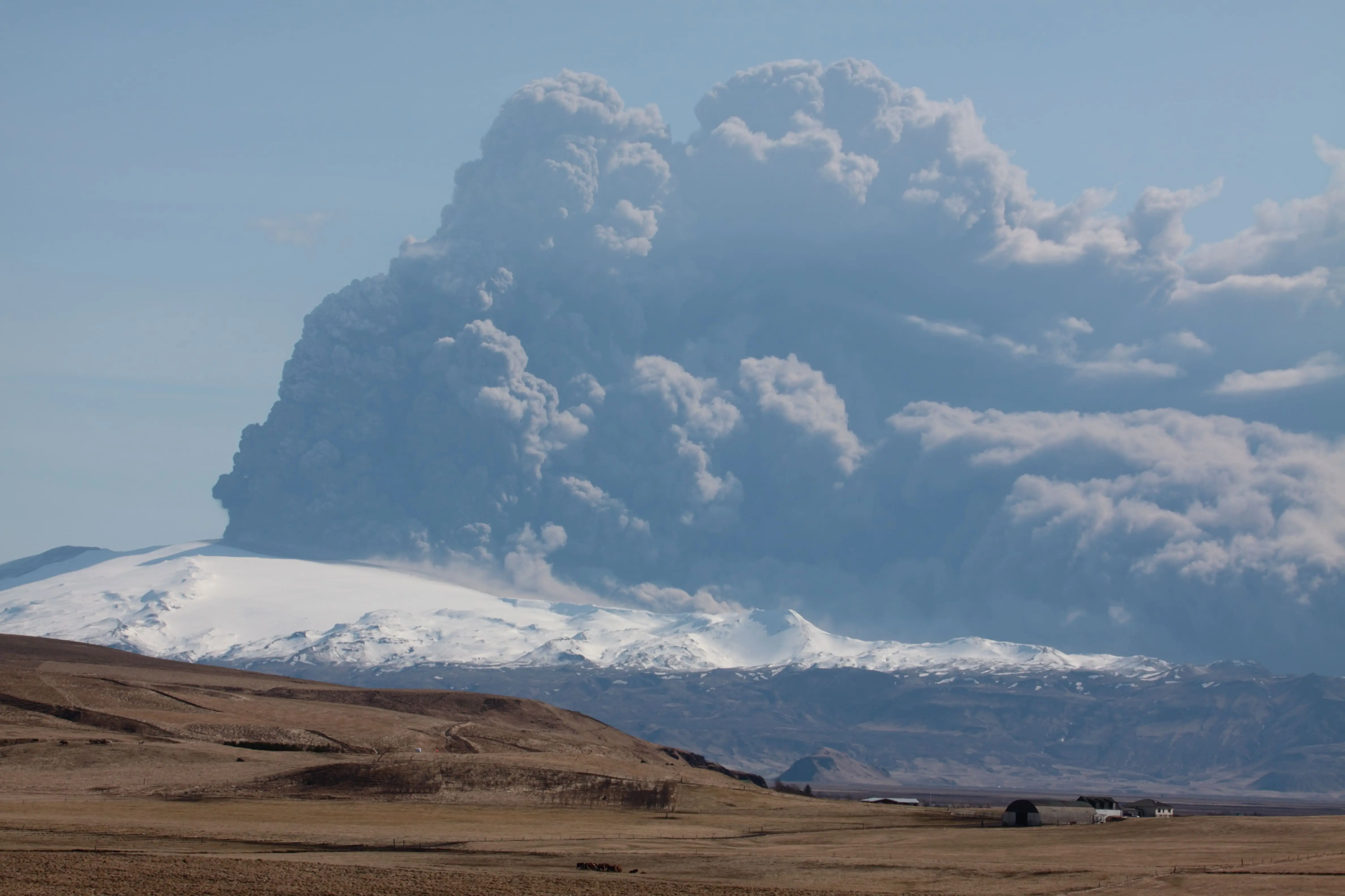
The 2010 iceland volcanic eruption occurred in two distinct phases. The first began on 20 March 2010 at Fimmvörðuháls, a mountain pass between Eyjafjallajökull and Mýrdalsjökull glaciers, producing lava flows but little ash. The second and more disruptive phase began on 14 April 2010 when magma melted through the summit glacier, generating a fine-grained ash column that rose to between 8 and 9 kilometres altitude.
The geological mechanism behind the ash cloud is the critical detail that most accounts skip. When magma rises beneath a glacier, the sudden contact between molten rock and ice produces an explosive flash-vaporisation. The steam explosion shatters the magma into extremely fine particles — far smaller than ash produced by dry eruptions. These particles, typically less than 0.1 millimetres in diameter, are light enough to remain suspended in the upper atmosphere for days and can travel thousands of kilometres on prevailing winds.
Eyjafjallajökull is a stratovolcano sitting beneath the Eyjafjallajökull glacier in southern Iceland, approximately 150 kilometres east of Reykjavík. The glacier covering its 1,651-metre summit was the specific ingredient that turned what would have been a routine Icelandic eruption into a continental-scale air traffic crisis.
The volcano in iceland that erupted in 2010 had in fact erupted in the same sequence before: historical records show Eyjafjallajökull erupted in 920 AD, 1612, and 1821–1823, the last of which also involved a subglacial phase. The 2010 eruption was notable not for its size — it was geologically modest — but for its atmospheric chemistry and timing.
The Ash Cloud Iceland 2010: Why European Airspace Closed
The ash cloud iceland 2010 forced the closure of European airspace because volcanic ash is catastrophically dangerous to jet engines — it melts inside the combustor and re-solidifies on turbine blades, causing engine failure. Aviation authorities operated under a zero-tolerance policy for ash density at the time, closing airspace even at low concentrations.
The London Volcanic Ash Advisory Centre, part of the UK Met Office, issued dispersal forecasts that were used to determine safe and unsafe zones across Europe. Eurocontrol, the European air traffic coordination body, coordinated the resulting closures from 15–21 April 2010 — the longest closure of European airspace since the Second World War.
At its peak, the ash cloud covered much of northern and central Europe. The BBC's archive coverage from that week documented over 100,000 cancelled flights and an aviation industry loss later estimated by the International Air Transport Association at €1.3 billion for the six-day closure period.
The closure exposed a significant gap in volcanic risk assessment methodology. The original zero-tolerance threshold was based on older engine technology and limited ash-density modelling. In the years following 2010, aviation authorities revised their guidelines, introducing concentration-based thresholds that allow flights in airspace with measurable but low ash concentrations. Iceland itself contributed scientific data from the eruption to these revised frameworks.
Iceland Volcano 2010: The Geological Context
The iceland volcano 2010 eruption occurred because Eyjafjallajökull sits on the Mid-Atlantic Ridge, where the North American and Eurasian tectonic plates diverge. Iceland is the only location on Earth where this ridge rises above sea level, making the entire island a site of continuous volcanic activity driven by plate tectonics combined with a deep mantle plume.
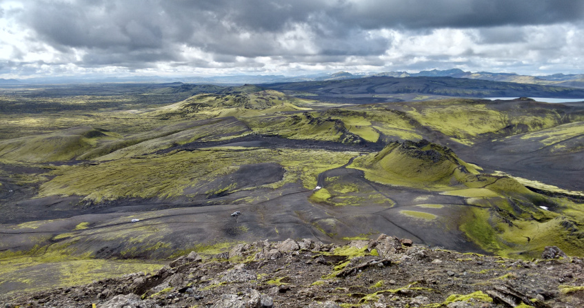
Understanding the 2010 event requires understanding this geological foundation. Iceland averages 20–25 volcanic eruptions per century across its approximately 130 volcanic systems, according to the Icelandic Meteorological Office. Most of these eruptions are modest by global standards — effusive basaltic flows rather than explosive events. What made 2010 exceptional was the specific combination of subglacial eruption style and atmospheric conditions.
Eyjafjallajökull shares a volcanic history with its neighbour Katla, covered by the Mýrdalsjökull glacier to the east. The two volcanoes are geologically connected through a shared magmatic system, and historical records show that every documented eruption of Eyjafjallajökull has been followed by a Katla eruption within a few years. The 1821–1823 Eyjafjallajökull eruption triggered a Katla eruption in 1823. After 2010, Iceland's volcanology community monitored Katla closely — it remains one of Iceland's most closely watched systems. For the current monitoring status of Katla and all Icelandic volcanic systems, the Icelandic Meteorological Office publishes live seismic and deformation data.
The initial phase of the 2010 eruption at Fimmvörðuháls produced lava flows into Þórsmörk valley and was actually accessible to hikers at certain points — a remarkable contrast to the disruption that followed. The phase attracted thousands of visitors to watch lava flows at close range before the summit phase began and transformed the event into a global crisis.
For the deeper geological context of why Iceland produces eruptions like this — and what the Mid-Atlantic Ridge means for the island's future — see our article on Tectonic Plates in Iceland: Why the Island Is Pulling Apart.
How Many People Died in the Eyjafjallajökull Eruption 2010?
No direct fatalities resulted from the Eyjafjallajökull eruption itself. The eruption caused no deaths from lava, ash fall, or related volcanic hazards. The impact was economic and logistical: an estimated 10 million passengers were affected by flight cancellations, and the aviation industry absorbed losses of approximately €1.3 billion during the six-day airspace closure.
Farmers near the volcano's flanks experienced significant livestock losses from fluoride contamination in ash fall — a pattern consistent with Icelandic eruptions more broadly. Locally, ash deposits damaged crops and contaminated water sources in the south of Iceland. The region around Þórsmörk received jökulhlaup (glacial outburst flood) activity from meltwater generated during the eruption, causing localised damage to infrastructure.
The death toll from volcanic eruptions in Iceland's modern history is extremely low compared to the country's eruption frequency. Iceland's combination of a small population, well-established monitoring infrastructure, and evacuation protocols has consistently limited casualties even during significant events. This stands in contrast to the economic disruption, which in 2010 demonstrated that a geologically modest eruption in the right atmospheric circumstances can have consequences disproportionate to its physical scale.
What Was the Worst Volcanic Eruption in Iceland History?
The worst volcanic eruption in Iceland's recorded history — by human impact — was the Laki fissure eruption of 1783–1784, not Eyjafjallajökull. The Laki eruption produced approximately 14 cubic kilometres of lava over eight months, released toxic fluorine- and sulphur-bearing gases that poisoned approximately 75% of Iceland's livestock, and caused a famine that killed an estimated 25% of Iceland's population.
The 1783 Laki eruption also had global consequences — the sulphur dioxide it released into the atmosphere caused a demonstrable cooling effect across the Northern Hemisphere and contributed to harvest failures in Europe that some historians have linked to the social conditions preceding the French Revolution. The scale of Laki dwarfs Eyjafjallajökull in every geological and human metric. For the full story of that event, our article Laki: The Eruption That Changed Global History covers the science and consequences in depth.
Iceland's volcanic history extends well beyond these two events. The Smithsonian Institution's Global Volcanism Program maintains the most comprehensive archive of Iceland's eruptive record.
Is It Safe to Travel to Iceland in 2026?
Iceland is safe to travel to in 2026. Volcanic activity on the Reykjanes Peninsula since 2021 has not affected Reykjavík, the major tourist routes, or international flight operations at Keflavík International Airport. The eruptions are fissure-type events producing lava flows rather than ash clouds, and are geographically concentrated southwest of the capital.
The 2010 eruption was unusual in Icelandic terms precisely because its ash cloud was an exception — the result of a subglacial explosion rather than the basaltic effusive style that characterises most modern Icelandic eruptions. The current Reykjanes Peninsula eruptive cycle involves lava flows in an uninhabited area with no significant ash impact on aviation.
For current eruption status, road access conditions, and any travel advisories related to the Reykjanes Peninsula, check Icelandic Civil Protection at almannavarnir.is and safetravel.is on the day of your visit.
Experience Iceland's Volcanic Forces at Harpa
Volcano Express, inside Harpa Concert Hall on Reykjavík's waterfront at Austurbakki 2, is a cinematic motion-simulator volcano experience that puts the geological forces behind events like Eyjafjallajökull 2010 into physical, sensory form. The included 30-minute pre-show features live eruption footage, short films on Iceland's volcanic systems, an interactive eruption map, a live earthquake monitor, and the Instacrater photo experience — followed by a 10-minute ride with real heat effects and dynamic motion seating. Volcano Express runs daily 10:00–20:00 on floor K2, indoors and weather-independent year-round. If the 2010 eruption is what brought you to this page, this is where that story becomes tangible.


.jpg)